IMAGES TAKEN NEAR TO
Old Dixton Road, MONMOUTH, NP25 3SG
Introduction
This page details the photographs taken nearby to Old Dixton Road, NP25 3SG by members of the Geograph project.
The Geograph project started in 2005 with the aim of publishing, organising and preserving representative images for every square kilometre of Great Britain, Ireland and the Isle of Man.

There are currently over 7.5m images from over14,400 individuals and you can help contribute to the project by visiting https://www.geograph.org.uk
Image Map
Images are licensed for reuse under creativecommons.org/licenses/by-sa/2.0
Notes
- Clicking on the map will re-center to the selected point.
- The higher the marker number, the further away the image location is from the centre of the postcode.
Image Listing (60 Images Found)
Images are licensed for reuse under creativecommons.org/licenses/by-sa/2.0
Image
Details
Distance
1
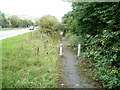
Path to the eastern side of Old Dixton Road, Monmouth
The present course of the A40 cuts across the former route of Old Dixton Road.
Both ends of the severed road now end in footpaths. This footpath, on the east side of the A40, leads to the short remnant of the eastern end of Old Dixton Road.
Image: © Jaggery
Taken: 12 Sep 2010
0.04 miles
2
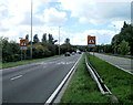
A40 Monmouth : traffic lights ahead
Signs alert drivers heading SW along the A40 into Monmouth that there are traffic lights 600 yards ahead.
Image: © Jaggery
Taken: 12 Sep 2010
0.05 miles
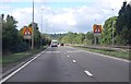

5

Old Dixton Road, Monmouth
A view SW along Old Dixton Road which here is alongside the A40, out of shot on the left.
Image: © Jaggery
Taken: 24 Apr 2011
0.07 miles
6
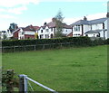
Dixton Road houses near the edge of Monmouth
Houses on the north side of Dixton Road, at the edge of fields.
Image: © Jaggery
Taken: 12 Sep 2010
0.09 miles
7
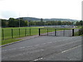
Entrance gate from Dixton Road to sports fields
The entrance road is to sports fields on the NE side of Monmouth Comprehensive School.
Image: © Jaggery
Taken: 12 Sep 2010
0.09 miles
8
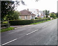
Eastermost houses on Dixton Road, Monmouth
These are the first houses reached along Dixton Road on entering Monmouth from the east.
Image: © Jaggery
Taken: 12 Sep 2010
0.09 miles
9
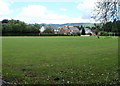
Sports field, eastern Monmouth
Located between the A40 and Dixton Road (A466), the field is used for various sports. In this photo, taken in September, football goalposts can be seen near the right edge.
Image: © Jaggery
Taken: 12 Sep 2010
0.09 miles
10
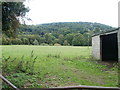
Riverside field, Monmouth
Viewed from the footpath http://www.geograph.org.uk/photo/2099510 from the A40 to the eastern portion of Old Dixton Road. The trees on the far side of the field border the River Wye.
Image: © Jaggery
Taken: 12 Sep 2010
0.10 miles