IMAGES TAKEN NEAR TO
The Kymin, MONMOUTH, NP25 3SD
Introduction
This page details the photographs taken nearby to The Kymin, NP25 3SD by members of the Geograph project.
The Geograph project started in 2005 with the aim of publishing, organising and preserving representative images for every square kilometre of Great Britain, Ireland and the Isle of Man.

There are currently over 7.5m images from over14,400 individuals and you can help contribute to the project by visiting https://www.geograph.org.uk
Image Map
Images are licensed for reuse under creativecommons.org/licenses/by-sa/2.0
Notes
- Clicking on the map will re-center to the selected point.
- The higher the marker number, the further away the image location is from the centre of the postcode.
Image Listing (89 Images Found)
Images are licensed for reuse under creativecommons.org/licenses/by-sa/2.0
Image
Details
Distance
2
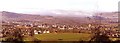
Monmouth from Garth Wood
on the Offa's Dyke Path
Image: © Tom Courtney
Taken: 22 Jun 1991
0.05 miles
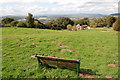
3
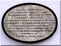
Plaque on the Naval Temple nr Monmouth
See picture Image] to see it in context.
Image: © Stuart Wilding
Taken: 29 Mar 2006
0.05 miles
4
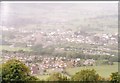
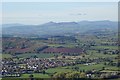
View from The Kymin
In the foreground is the town of Monmouth whilst in the distance the Black Mountains can be seen shrouded in showers.
Image: © Stuart Wilding
Taken: 29 Mar 2006
0.05 miles
5
View to the Black Mountains
View to the Black Mountains and in particular Sugar Loaf, viewed from The Kymin.
Image: © Philip Halling
Taken: 2 Nov 2018
0.05 miles
7
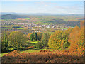
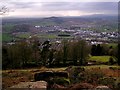
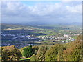
Autumn view from the Kymin - 1
Looking west, the colourful trees give way to Monmouth town, with the Black Mountains in the distance.
See Image for zoom view from the same position.
Image: © Trevor Rickard
Taken: 10 Nov 2010
0.12 miles
8
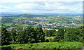
View west from The Kymin
In the foreground are the trees sheltering the houses on the Kymin Hill.
The middle distance is taken up with the town of Monmouth spread out on a welcome patch of July sunshine.
In the blue far distance are the hills around Abergavenny with Blorenge, Sugarloaf and Skirrid clear as well as Pen-y-fan and Corn Du just to the left of the Sugarloaf's cone. The Black Mountains and Hay Bluff are over to the right.
Image: © Jonathan Billinger
Taken: 20 Jul 2008
0.12 miles
9
View from The Kymin viewpoint
Beyond the immediate slopes you can see Monmouth, then across the patchwork of fields of Monmouthshire to the Blorenge, the Sugarloaf and Black Mountains.
Image: © Ruth Sharville
Taken: 19 Oct 2014
0.12 miles
10
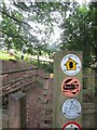
Kymin - Offas Dyke Path
This rural path leads from Monmouth town up to the scattered houses on Kymin hill. The footpath is also followed here by part of the Offa's Dyke Path (177 miles / 285 kilometres long) which loosely follows the English-Welsh border.
https://www.nationaltrail.co.uk/en_GB/trails/offas-dyke-path/
Image: © Colin Smith
Taken: 4 Aug 2023
0.13 miles