IMAGES TAKEN NEAR TO
Buckholt View, MONMOUTH, NP25 3AS
Introduction
This page details the photographs taken nearby to Buckholt View, NP25 3AS by members of the Geograph project.
The Geograph project started in 2005 with the aim of publishing, organising and preserving representative images for every square kilometre of Great Britain, Ireland and the Isle of Man.

There are currently over 7.5m images from over14,400 individuals and you can help contribute to the project by visiting https://www.geograph.org.uk
Image Map
Images are licensed for reuse under creativecommons.org/licenses/by-sa/2.0
Notes
- Clicking on the map will re-center to the selected point.
- The higher the marker number, the further away the image location is from the centre of the postcode.
Image Listing (17 Images Found)
Images are licensed for reuse under creativecommons.org/licenses/by-sa/2.0
Image
Details
Distance
1
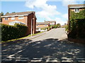
Lancaster Way, Osbaston
At the western edge of residential Osbaston, Lancaster Way climbs away from Osbaston Road.
Image: © Jaggery
Taken: 12 Sep 2010
0.03 miles
2
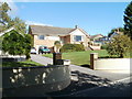
Bungalow, Osbaston Road
Located on the north side of Osbaston Road, between Lancaster Way and St Mary's Road.
Image: © Jaggery
Taken: 12 Sep 2010
0.09 miles
3
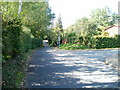
Osbaston Road heads for Osbaston Farm
Just beyond the right turn for Lancaster Way, http://www.geograph.org.uk/photo/2063706 Osbaston Road approaches a National Speed Limit sign at the SW edge of residential Osbaston. A short way ahead is Osbaston Farm.
Image: © Jaggery
Taken: 12 Sep 2010
0.11 miles
4
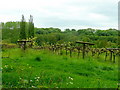
Vineyard opposite Great Osbaston Farm
Breaking into spring leaf in May 2009.
Image: © Jonathan Billinger
Taken: 22 May 2009
0.12 miles
5
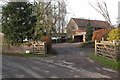
Osbaston Farm, Monmouth
Farm in the Monnow valley to the west of Monmouth.
Image: © Philip Halling
Taken: 22 Jan 2006
0.14 miles
6
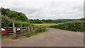
Footpath from Osbaston Road
Over one field to Forge Road and the Monnow.
Image: © Jonathan Billinger
Taken: 21 Jun 2021
0.15 miles
7
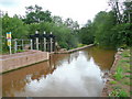
Osbaston Weir
Originally built in 1917 to supply hydro-electrice power, a fish pass has recently been added to enable salmon to enter the Monnow system.
Image: © Jonathan Billinger
Taken: 14 Jul 2009
0.16 miles
8
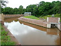
New fish pass at Osbaston Weir 2
Recently completed, this construction allows salmon to enter the Monnow system by negotiating the weir built 90 years ago.
Image: © Jonathan Billinger
Taken: 14 Jul 2009
0.16 miles
9
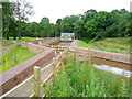
New fish pass at Osbaston Weir
Recently completed, this construction allows salmon to enter the Monnow system by negotiating the weir built 90 years ago.
Image: © Jonathan Billinger
Taken: 14 Jul 2009
0.18 miles
10
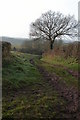
Green lane near Osbaston
Green lane from Osbaston to Great Manson Farm.
Image: © Philip Halling
Taken: 22 Jan 2006
0.19 miles