IMAGES TAKEN NEAR TO
Lawrence Terrace, NEW TREDEGAR, NP24 6LR
Introduction
This page details the photographs taken nearby to Lawrence Terrace, NP24 6LR by members of the Geograph project.
The Geograph project started in 2005 with the aim of publishing, organising and preserving representative images for every square kilometre of Great Britain, Ireland and the Isle of Man.

There are currently over 7.5m images from over14,400 individuals and you can help contribute to the project by visiting https://www.geograph.org.uk
Image Map
Images are licensed for reuse under creativecommons.org/licenses/by-sa/2.0
Notes
- Clicking on the map will re-center to the selected point.
- The higher the marker number, the further away the image location is from the centre of the postcode.
Image Listing (18 Images Found)
Images are licensed for reuse under creativecommons.org/licenses/by-sa/2.0
Image
Details
Distance
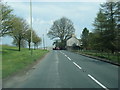
2
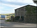
The remaining house in Troedrhiwfuwch
Most of the village was abandoned and demolished in the late 1970s/early 1980s because of the risk caused by moving land above. However, the former post office remains.
Image: © Gareth James
Taken: 30 Aug 2019
0.05 miles
3
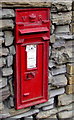
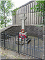
Victorian postbox in Troedrhiwfuwch
In the wall of the former village post office. https://www.geograph.org.uk/photo/5918373
Image: © Jaggery
Taken: 27 Jul 2018
0.05 miles
4
Troedrhiwfuwch War Memorial
Viewed across the A469. https://www.geograph.org.uk/photo/5918363 to a closer view.
Located between Pontlottyn and New Tredegar, the once thriving mining village of Troedrhiwfuwch was gradually abandoned in the late 20th century as a shifting hillside to its west threatened to engulf the village. Most of the village's houses were demolished by the 1980s.
Image: © Jaggery
Taken: 27 Jul 2018
0.05 miles
5
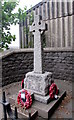
Troedrhiwfuwch War Memorial detail
https://www.geograph.org.uk/photo/5918208 to a broader view.
Image: © Jaggery
Taken: 27 Jul 2018
0.05 miles
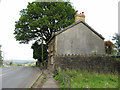
6
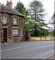
Former village post office, Troedrhiwfuwch
Viewed across the A469 in July 2018. The postbox is Victorian. https://www.geograph.org.uk/photo/5918380
Located between Pontlottyn and New Tredegar, the once thriving mining village of Troedrhiwfuwch was gradually abandoned in the late 20th century as a shifting hillside to its west threatened to engulf the village. Most of the village's houses were demolished by the 1980s.
Image: © Jaggery
Taken: 27 Jul 2018
0.06 miles
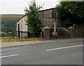
8
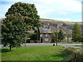
Former Post Office, Troedrhiwfuwch
This is one of the two remaining occupied houses in Troedrhiwfuwch. The rest of this small village was demolished in the 20th century due to landslips on the mountainside.
The Victorian post box is still in use. http://www.geograph.org.uk/photo/1032661
A war memorial for the village is situated behind the tree on the left. http://www.geograph.org.uk/photo/1032649
Image: © Robin Drayton
Taken: 10 Oct 2008
0.06 miles
9
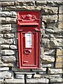
Victorian postbox, Troedrhiwfuwch
With only two occupied houses in the village, this post box must be a good candidate for being the least used in the UK. http://www.geograph.org.uk/photo/1032673
Image: © Robin Drayton
Taken: 10 Oct 2008
0.07 miles
10
War memorial, Troedrhiwfuwch
A poignant reminder, not only of those from Troedrhiwfuwch who gave their lives for their country, but also that this was once a small thriving village. http://www.geograph.org.uk/photo/1032673
Image: © Robin Drayton
Taken: 10 Oct 2008
0.07 miles