IMAGES TAKEN NEAR TO
Upper Road, NEW TREDEGAR, NP24 6ED
Introduction
This page details the photographs taken nearby to Upper Road, NP24 6ED by members of the Geograph project.
The Geograph project started in 2005 with the aim of publishing, organising and preserving representative images for every square kilometre of Great Britain, Ireland and the Isle of Man.

There are currently over 7.5m images from over14,400 individuals and you can help contribute to the project by visiting https://www.geograph.org.uk
Image Map
Images are licensed for reuse under creativecommons.org/licenses/by-sa/2.0
Notes
- Clicking on the map will re-center to the selected point.
- The higher the marker number, the further away the image location is from the centre of the postcode.
Image Listing (160 Images Found)
Images are licensed for reuse under creativecommons.org/licenses/by-sa/2.0
Image
Details
Distance
1
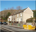
Short row of houses, Upper Road, Cwmsyfiog
Viewed from a small parking area on the side of Upper Road.
Image: © Jaggery
Taken: 20 Jan 2011
0.05 miles
2
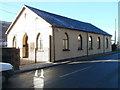
Bethania Pentecostal Church, Cwmsyfiog
Located on Upper Road, Cwmsyfiog, just south of Queen's Road.
http://www.geograph.org.uk/photo/2198800 to a view from the opposite end.
Image: © Jaggery
Taken: 20 Jan 2011
0.06 miles
3
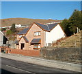
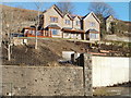
Recently built house, Cwmsyfiog
Viewed from the edge of Bethania Pentecostal Church. http://www.geograph.org.uk/photo/2278548
There was no boundary sign nearby to determine whether the house is at the northern end of Upper Road, Cwmsyfiog, or the southern end of Queen's Road, New Tredegar.
Image: © Jaggery
Taken: 20 Jan 2011
0.06 miles
5
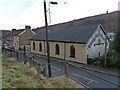
Bethania Pentecostal Church, Cwmsyfiog
The mural that is painted on the end of the church building and proclaims that "Jesus Christ is Lord" was once very prominent to all drivers travelling southwards along this road. However, it has now faded with time and is partially obscured by trees.
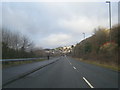
This was once the main road on the eastern side of the Rhymney Valley but has been superseded by White Rose Way http://www.geograph.org.uk/photo/2198787 .
Image: © Robin Drayton
Taken: 15 Dec 2010
0.07 miles
6
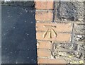
Ordnance Survey Cut Mark
This OS cut mark can be found on the old school wall. It marks a point 209.977m above mean sea level.
Image: © Adrian Dust
Taken: 12 Feb 2021
0.08 miles
7
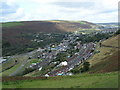
Cwmsyfiog house with a view across Brithdir
Recently-built house on an elevated site on the east side of Upper Road, Cwmsyfiog, facing the neighbouring village of Brithdir.
Image: © Jaggery
Taken: 20 Jan 2011
0.08 miles

10
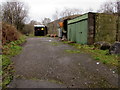
Buildings near the eastern edge of Brithdir
Located near this http://www.geograph.org.uk/photo/4806293 village boundary sign. I couldn't decide whether these buildings are derelict or merely closed for the weekend. A building on the right is damaged. A notice on the black building shows
KEEP OUT GARAGE IN USE 24 HOURS.
Image: © Jaggery
Taken: 23 Jan 2016
0.10 miles