1
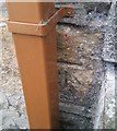
Ordnance Survey Cut Mark
This OS cut mark can be found on No78 Drysiog Street. It marks a point 347.036m above mean sea level.
Image: © Adrian Dust
Taken: 18 Aug 2018
0.04 miles
2
Ordnance Survey Cut Mark
This OS cut mark can be found on No1 Fern Cottage, Mount Street. It marks a point 327.441m above mean sea level.
Image: © Adrian Dust
Taken: 18 Aug 2018
0.06 miles
3
Ebbw Vale Literary and Scientific Institute
This building known locally as "The Stute" was established in c1849.
The main road along side this building is Church Street.
Image: © bracaragh
Taken: 20 Mar 2008
0.07 miles
4
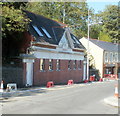
Cyfleusterau cyhoeddus wedi eu haddasu / Converted public conveniences
This building is now an architect's studio, but the separate entrances at each end and the inscription EVUDC suggest a different former use.
Image: © Ceri Thomas
Taken: 5 Aug 2010
0.07 miles
5
1st Ebbw Vale (Penuel) Scout Group HQ, Ebbw Vale
Formed in 1910, the 1st Ebbw Vale Scout Group had its headquarters in various locations in Ebbw Vale, before buying and converting this building, the former Penuel chapel located on the corner of Church Street and Mount Street. When the building was officially opened as their new HQ in late 1989, the group added (Penuel) to its name.
Image: © Jaggery
Taken: 29 Sep 2011
0.08 miles
6
Mount Street, Ebbw Vale
Houses on the south side of Mount Street, a steep side street viewed from Church Street.
Image: © Jaggery
Taken: 29 Sep 2011
0.08 miles
7
Former Armoury Hill bank building converted to flats, Ebbw Vale
Though the lettering has been removed, the outline of BARCLAYS BANK LIMITED remains on the building, Armoury Court, Armoury Hill, now converted to flats.
Image: © Jaggery
Taken: 29 Sep 2011
0.09 miles
8
Armoury Studios Ebbw Vale
Architects' premises at 19 Armoury Terrace. This is a converted public convenience. Below the conspicuous 1932 on the wall, whitewashed letters spell out EVUDC, (Ebbw Vale Urban District Council). When the council was abolished in 1974, following local government reorganisation, its functions passed to the new Borough of Blaenau Gwent, now (2011) known as Blaenau Gwent County Borough Council.
Image: © Jaggery
Taken: 29 Sep 2011
0.09 miles
9
Southern end of Eureka Place, Ebbw Vale
The houses are set several metres above road level. The B4478 Church Street becomes the B4478 Eureka Place ahead.
Image: © Jaggery
Taken: 29 Sep 2011
0.09 miles
10
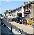
Church Street, Ebbw Vale
The east side of the street, viewed from opposite Canolfan Canu. http://www.geograph.org.uk/photo/2625560
Image: © Jaggery
Taken: 29 Sep 2011
0.11 miles


