IMAGES TAKEN NEAR TO
Prince Philip Avenue, EBBW VALE, NP23 5DY
Introduction
This page details the photographs taken nearby to Prince Philip Avenue, NP23 5DY by members of the Geograph project.
The Geograph project started in 2005 with the aim of publishing, organising and preserving representative images for every square kilometre of Great Britain, Ireland and the Isle of Man.

There are currently over 7.5m images from over14,400 individuals and you can help contribute to the project by visiting https://www.geograph.org.uk
Image Map
Images are licensed for reuse under creativecommons.org/licenses/by-sa/2.0
Notes
- Clicking on the map will re-center to the selected point.
- The higher the marker number, the further away the image location is from the centre of the postcode.
Image Listing (54 Images Found)
Images are licensed for reuse under creativecommons.org/licenses/by-sa/2.0
Image
Details
Distance
1
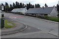
Slate roofs and a 20 zone in Garnlydan
Viewed across Prince Philip Avenue from the corner of Cynan Close.
Image: © Jaggery
Taken: 16 May 2014
0.04 miles
2
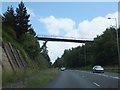
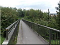
Elevated foot- and cycle- bridge over A465
This elevated foot- and cycle- bridge provides a link between Garn-Lydan and Carmeltown, on the edge of Beaufort. Users are caged for safety.
Image: © David Smith
Taken: 7 Jul 2011
0.05 miles
3
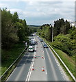
A465 skirts the southern edge of Garnlydan
Looking WSW along the A465 Heads of the Valleys Road from this http://www.geograph.org.uk/photo/3982218 bridge.
Houses at the edge of Garnlydan are on the right. Cones block the central lane of three.
Image: © Jaggery
Taken: 16 May 2014
0.05 miles
4
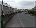
Queensway houses, Garnlydan
Out of shot, several side streets connect to Queensway which follows a roughly horseshoe-shaped course on the west side of Llangynidr Road. There are two junctions with Llangyndir Road, about 250 metres apart, at the two ends of the horseshoe.
Image: © Jaggery
Taken: 16 May 2014
0.06 miles
5
A465 footbridge, Garnlydan
Accessed on this side from Prince Philip Avenue in Garnlydan, the footbridge across the A465
Heads of the Valleys Road leads to Carmeltown at the edge of Beaufort.
Image: © Jaggery
Taken: 16 May 2014
0.07 miles
6
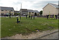
Exercise equipment, Garnlydan
Alongside a row of shops in Queensway.
Image: © Jaggery
Taken: 16 May 2014
0.08 miles
7
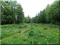
Track junction in Carmeltown
Two tracks converge on the south side of a footbridge http://www.geograph.org.uk/photo/3991559 over the A465 Heads of the Valleys Road.
Image: © Jaggery
Taken: 16 May 2014
0.09 miles
8
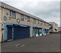
Infoshop, Garnlydan
Located in a row of shops in Queensway. No information was available from the Infoshop when this shot was taken (late morning on a Friday), not even when the Infoshop was next open...
Image: © Jaggery
Taken: 16 May 2014
0.09 miles
9
End of a coned-off section of the A465, Garnlydan
Viewed from this http://www.geograph.org.uk/photo/3991559 footbridge. The long line of red and white cones blocking off the middle lane of the Heads of the Valleys Road behind the camera http://www.geograph.org.uk/photo/3991561 ends in the middle distance.
Image: © Jaggery
Taken: 16 May 2014
0.09 miles
10

Istanbul in Garnlydan
Kebab and pizza takeaway at the eastern end of a row of shops in Queensway.
Image: © Jaggery
Taken: 16 May 2014
0.10 miles