IMAGES TAKEN NEAR TO
Woodland Terrace, EBBW VALE, NP23 4QL
Introduction
This page details the photographs taken nearby to Woodland Terrace, NP23 4QL by members of the Geograph project.
The Geograph project started in 2005 with the aim of publishing, organising and preserving representative images for every square kilometre of Great Britain, Ireland and the Isle of Man.

There are currently over 7.5m images from over14,400 individuals and you can help contribute to the project by visiting https://www.geograph.org.uk
Image Map
Images are licensed for reuse under creativecommons.org/licenses/by-sa/2.0
Notes
- Clicking on the map will re-center to the selected point.
- The higher the marker number, the further away the image location is from the centre of the postcode.
Image Listing (25 Images Found)
Images are licensed for reuse under creativecommons.org/licenses/by-sa/2.0
Image
Details
Distance
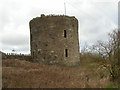
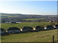
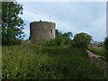
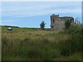
2
Round Tower at Nantyglo
Nantyglo Round Towers are located at Roundhouse Farm, Nantyglo near Brynmawr in the borough of Blaenau Gwent in the South Wales Valleys. The two fortified towers were constructed in 1816 during the period of national unrest due to high wheat prices following the end of the Napoleonic wars, by the ironmasters Matthew Wayne (1780–1853) and Joseph Bailey, beside Nantyglo House or Ty Mawr as barracks for the militia and places of retreat.
They are believed to be the last fortifications of their type built in Britain. One of the towers remains intact today whilst the other is ruinous having been partly demolished in a search for scrap iron in the 1940s. Neither is open to the public though they can be viewed from nearby
Image: © Rude Health
Taken: 19 Sep 2008
0.03 miles
3
A Round Tower at Nantyglo
Built as a defensive measure in the early 19th century by ironmasters. A second tower is at Image]
Image: © David Smith
Taken: 7 Jul 2011
0.04 miles
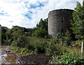
4
A Nantyglo Rounhouse
Situated on the north-east of Roundhouse Farm.
Image: © Robin Drayton
Taken: 5 Sep 2013
0.04 miles
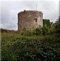
5
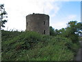
NE roundhouse, Nantyglo
This is one of two roundhouses dating from the early 19th century. The other one is located 125 metres to the SW. They are not accessible to visitors as they are located in private property. This view was taken from a muddy public track.
The Blaenau Gwent County Borough Council website states:
"The Nantyglo Roundhouse complex is a unique relic of the Industrial Revolution. It was built in about 1816 by Joseph and Crawshay Bailey, the Ironmasters of the Nantyglo Ironworks, as a defended refuge against armed revolt by their workforce. In effect, it was the last private castle built in Britain. No other site in Wales gives so stark a reminder of the bitter conflict between Ironmasters and workforce. The towers symbolise the social upheaval which gave birth to the Chartist Insurrection and which would eventually create the modern labour movement. Properly conserved and consolidated, the Roundhouse Complex has huge potential as a heritage centre telling the turbulent story of a key period in Welsh history. It would serve as an invaluable educational resource for local people and an attraction for visitors from further afield."
Image: © Jaggery
Taken: 18 Sep 2013
0.04 miles
6

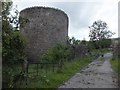
Roundhouse Farm Nantyglo
This is the NE side of the farm viewed from Waun Ebbw Road.
The edge of a roundhouse http://www.geograph.org.uk/photo/3661004 is on the left.
Image: © Jaggery
Taken: 18 Sep 2013
0.05 miles
7
SW roundhouse, Nantyglo
This is one of two roundhouses dating from the early 19th century. The other one is located 125 metres to the NE. They are not accessible to visitors as they are located in private property. This view was taken from a muddy public track.
The Blaenau Gwent County Borough Council website states:
"The Nantyglo Roundhouse complex is a unique relic of the Industrial Revolution. It was built in about 1816 by Joseph and Crawshay Bailey, the Ironmasters of the Nantyglo Ironworks, as a defended refuge against armed revolt by their workforce. In effect, it was the last private castle built in Britain. No other site in Wales gives so stark a reminder of the bitter conflict between Ironmasters and workforce. The towers symbolise the social upheaval which gave birth to the Chartist Insurrection and which would eventually create the modern labour movement. Properly conserved and consolidated, the Roundhouse Complex has huge potential as a heritage centre telling the turbulent story of a key period in Welsh history. It would serve as an invaluable educational resource for local people and an attraction for visitors from further afield."
Image: © Jaggery
Taken: 18 Sep 2013
0.09 miles
8
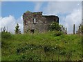
One of the Round Towers of Nantyglo
This tower is not so well preserved as the other, Image], at the north end of Round Tower Farm
Image: © David Smith
Taken: 7 Jul 2011
0.09 miles
9
A Nantyglo Rounhouse
Situated on the south-west of Roundhouse Farm.
Image: © Robin Drayton
Taken: 5 Sep 2013
0.10 miles