SW roundhouse, Nantyglo
Introduction
The photograph on this page of SW roundhouse, Nantyglo by Jaggery as part of the Geograph project.
The Geograph project started in 2005 with the aim of publishing, organising and preserving representative images for every square kilometre of Great Britain, Ireland and the Isle of Man.

There are currently over 7.5m images from over 14,400 individuals and you can help contribute to the project by visiting https://www.geograph.org.uk
SW roundhouse, Nantyglo
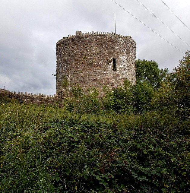
Image: © Jaggery Taken: 18 Sep 2013
This is one of two roundhouses dating from the early 19th century. The other one is located 125 metres to the NE. They are not accessible to visitors as they are located in private property. This view was taken from a muddy public track. The Blaenau Gwent County Borough Council website states: "The Nantyglo Roundhouse complex is a unique relic of the Industrial Revolution. It was built in about 1816 by Joseph and Crawshay Bailey, the Ironmasters of the Nantyglo Ironworks, as a defended refuge against armed revolt by their workforce. In effect, it was the last private castle built in Britain. No other site in Wales gives so stark a reminder of the bitter conflict between Ironmasters and workforce. The towers symbolise the social upheaval which gave birth to the Chartist Insurrection and which would eventually create the modern labour movement. Properly conserved and consolidated, the Roundhouse Complex has huge potential as a heritage centre telling the turbulent story of a key period in Welsh history. It would serve as an invaluable educational resource for local people and an attraction for visitors from further afield."
Images are licensed for reuse under creativecommons.org/licenses/by-sa/2.0
Image Location
Latitude
51.784383
Longitude
-3.176802