IMAGES TAKEN NEAR TO
Old Blaenavon Road, EBBW VALE, NP23 4DX
Introduction
This page details the photographs taken nearby to Old Blaenavon Road, NP23 4DX by members of the Geograph project.
The Geograph project started in 2005 with the aim of publishing, organising and preserving representative images for every square kilometre of Great Britain, Ireland and the Isle of Man.

There are currently over 7.5m images from over14,400 individuals and you can help contribute to the project by visiting https://www.geograph.org.uk
Image Map
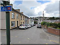
Images are licensed for reuse under creativecommons.org/licenses/by-sa/2.0
Notes
- Clicking on the map will re-center to the selected point.
- The higher the marker number, the further away the image location is from the centre of the postcode.
Image Listing (221 Images Found)
Images are licensed for reuse under creativecommons.org/licenses/by-sa/2.0
Image
Details
Distance
1
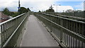
Footbridge access ramp, Brynmawr
From Old Blaen-Afon Road to this http://www.geograph.org.uk/photo/5503963 footbridge over the A467.
Image: © Jaggery
Taken: 18 Aug 2017
0.01 miles
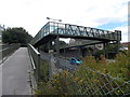
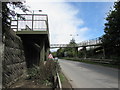
2
Footbridge over the A467, Brynmawr
The A467 was built through the course of the road now named Old Blaenavon Road.
The footbridge gives walkers access to both sides of the severed road.
Image: © Jaggery
Taken: 14 Sep 2013
0.02 miles
3
Footbridge over the A467, Brynmawr
The A467 was built through the course of the road now named Old Blaenavon Road.
The footbridge gives walkers and wheelchair users access to both sides of the severed road.
Image: © Jaggery
Taken: 14 Sep 2013
0.02 miles
4
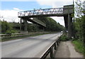
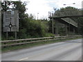
North side of an A467 footbridge, Brynmawr
Old maps show that the A467 here follows the route of a dismantled railway.
Image: © Jaggery
Taken: 18 Aug 2017
0.02 miles
5
South side of an A467 footbridge, Brynmawr
Old maps show that the A467 here follows the route of a dismantled railway.
Image: © Jaggery
Taken: 18 Aug 2017
0.02 miles
6
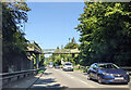
Footbridge over the A467 in Brynmawr, heading north
Image: © Rob Purvis
Taken: 14 Sep 2022
0.02 miles
7
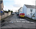
Old Blaen-Afon Road towards Gordon Terrace, Brynmawr
Viewed across Greenland Road looking past a Royal Mail van.
Image: © Jaggery
Taken: 2 Feb 2016
0.02 miles
8
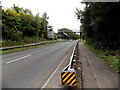
Grimy directions sign near an A467 footbridge, Brynmawr
Facing southbound traffic on the A467 on the approach to the roundabout at the B4248 crossroads.
Image: © Jaggery
Taken: 18 Aug 2017
0.02 miles
9
Cycle route 46 direction sign, Old Blaen-Afon Road, Brynmawr
Viewed in August 2017. The Sustrans website states that National Cycle Network Route 46 will connect Bromsgrove with Neath when complete.
Image: © Jaggery
Taken: 18 Aug 2017
0.02 miles
10
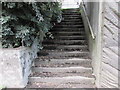
Steps up from the A467, Brynmawr
Ascending to Old Blaen-Afon Road from the west side of the A467.
Image: © Jaggery
Taken: 18 Aug 2017
0.02 miles