IMAGES TAKEN NEAR TO
Llechryd, Rhymney, TREDEGAR, NP22 5QY
Introduction
This page details the photographs taken nearby to NP22 5QY by members of the Geograph project.
The Geograph project started in 2005 with the aim of publishing, organising and preserving representative images for every square kilometre of Great Britain, Ireland and the Isle of Man.

There are currently over 7.5m images from over14,400 individuals and you can help contribute to the project by visiting https://www.geograph.org.uk
Image Map
Images are licensed for reuse under creativecommons.org/licenses/by-sa/2.0
Notes
- Clicking on the map will re-center to the selected point.
- The higher the marker number, the further away the image location is from the centre of the postcode.
Image Listing (21 Images Found)
Images are licensed for reuse under creativecommons.org/licenses/by-sa/2.0
Image
Details
Distance
1
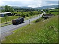
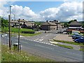
A469, Bute Town, Rhymney
The view down the upper part of the Rhymney Valley.
This road from the Heads of the Valleys road to Pontlottyn is the Rhymney bypass.
Taken from the edge of the reservoir http://www.geograph.org.uk/photo/3020517 .
Image: © Robin Drayton
Taken: 18 Jun 2012
0.15 miles
2
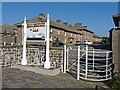
Information Board, Bute Town
A model village created in the early 1800s by the Marquis of Bute for workers in his ironworks. The designs of the forty seven cottages were based on those of the renaissance architect 'Palladio' who had developed his ideas from the ancient ruins of Rome. The village was intended to be much larger and be deemed a separate town but the development was never completed due to a slump in 1830.
(Extracted from the information board.)
Image: © Robin Drayton
Taken: 13 Oct 2010
0.21 miles
3
Butetown - Y Drenewydd, Rhymney
Named in honour of the Marquis of Bute, Scottish and South Wales industrialists and a 'new town' or model village to house workers in houses intended to keep them productive. But far ahead of its time.
Image: © Jeremy Bolwell
Taken: 16 Sep 2012
0.21 miles
4

Butetown/Drenewydd workers cottages
19c houses built for workers at the Rhymney Ironworks.
Image: © Robin Drayton
Taken: 3 Mar 2007
0.22 miles
5
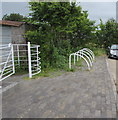
White cycle racks and kissing gate at the edge of Bute Town near Rhymney
Bute Town (Y Drenewydd in Welsh) is a small community dating from the early 19th century.
Image: © Jaggery
Taken: 11 Jul 2019
0.22 miles
6
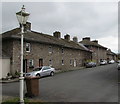
Grade II listed Lower Row, Bute Town near Rhymney
One of three rows of early 19th century ironworkers' houses
in the small community of Bute Town. All three rows are Grade II Listed.
Image: © Jaggery
Taken: 11 Jul 2019
0.22 miles
7

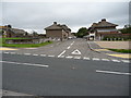
Grid across the access road to Bute Town near Rhymney
The A469 is in the background.
Image: © Jaggery
Taken: 11 Jul 2019
0.22 miles
8

Plague grave marker
This stone, which has no inscription and is in a field adjacent to Rhymney Cemetery, is said to be a plague grave marker.
Image: © Robin Drayton
Taken: 3 Mar 2007
0.23 miles
9
Bute Town, Rhymney
http://www.geograph.org.uk/photo/2113806
Viewed from the edge of the reservoir http://www.geograph.org.uk/photo/3020517 .
Image: © Robin Drayton
Taken: 18 Jun 2012
0.23 miles
