IMAGES TAKEN NEAR TO
Nant Celyn, TREDEGAR, NP22 5PD
Introduction
This page details the photographs taken nearby to Nant Celyn, NP22 5PD by members of the Geograph project.
The Geograph project started in 2005 with the aim of publishing, organising and preserving representative images for every square kilometre of Great Britain, Ireland and the Isle of Man.

There are currently over 7.5m images from over14,400 individuals and you can help contribute to the project by visiting https://www.geograph.org.uk
Image Map
Images are licensed for reuse under creativecommons.org/licenses/by-sa/2.0
Notes
- Clicking on the map will re-center to the selected point.
- The higher the marker number, the further away the image location is from the centre of the postcode.
Image Listing (86 Images Found)
Images are licensed for reuse under creativecommons.org/licenses/by-sa/2.0
Image
Details
Distance
1
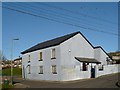
Emmanuel Baptist Church, Rhymney
The jackdaws were not straying far from their roost on this cold winter day.
Image: © Robin Drayton
Taken: 27 Dec 2008
0.05 miles
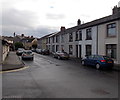
2
The junction of Havards Row and Beulah Street
Showing part of Emmanuel Baptist Church http://www.geograph.org.uk/photo/1112590 with Mountbatten at the centre right.
Image: © Robin Drayton
Taken: 22 Dec 2009
0.06 miles
3
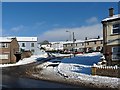
Evening view across the Rhymney Valley
Taken from a minor road above Pontlottyn.
The two rows of terraced houses at the lower right are Lady Tyler Terrace, Rhymney http://www.geograph.org.uk/photo/940212.
Image: © Robin Drayton
Taken: 5 Sep 2012
0.08 miles
4
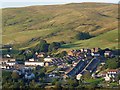
Rooftop view, Rhymney
This view over part of Rhymney is taken from an open space which was formerly Paddy's Pond.
The street in the foreground is Lady Tyler Terrace http://www.geograph.org.uk/photo/940212 , with Image and Beulah Street beyond.
Image: © Robin Drayton
Taken: 27 Dec 2008
0.08 miles
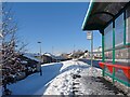
5
![Lady Tyler Terrace [2], Rhymney](https://s2.geograph.org.uk/geophotos/01/11/25/1112530_10235b3e_120x120.jpg)
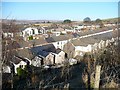
Lady Tyler Terrace [2], Rhymney
The view from the closed off end of this cul-de-sac of terraced houses.
Image: © Robin Drayton
Taken: 28 Dec 2008
0.08 miles
6
Ramsden Street, Rhymney
Ramsden Street is parallel with, and below, Havard's Row.
Image: © Jaggery
Taken: 17 Jan 2014
0.09 miles
7
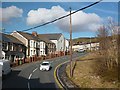
Brynteg Crescent, Rhymney
This is the B4257 which passes through the centre of Rhymney.
In the centre is Beulah Baptist Church http://www.geograph.org.uk/photo/691830 , with some of the houses in Beulah Street beyond.
Image: © Robin Drayton
Taken: 7 Feb 2014
0.10 miles
8
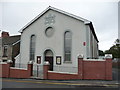
Beulah chapel, Rhymney
An English Baptist chapel on Beulah Street in Rhymney, part of the main street.
Each chapel served different parts of the local community; this one non-Welsh speaking in-comers from maybe the West Country or the Midlands. The date is 1866.
Image: © Jeremy Bolwell
Taken: 16 Sep 2012
0.10 miles
9
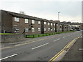
Havards Row flats, Rhymney
Flats on the northeast side of Havards Row. Whereas TV aerials are at roof level, as expected, the numerous satellite dishes are clustered near the centrepoint of each building's facade.
Image: © Jaggery
Taken: 7 May 2010
0.11 miles
10
Havards Row
Ramsden Street on the left and Calvary Evangelical Church http://www.geograph.org.uk/photo/691860 on the right.
Image: © Robin Drayton
Taken: 22 Dec 2009
0.11 miles