IMAGES TAKEN NEAR TO
Llys Joseph Parry, TREDEGAR, NP22 5EH
Introduction
This page details the photographs taken nearby to Llys Joseph Parry, NP22 5EH by members of the Geograph project.
The Geograph project started in 2005 with the aim of publishing, organising and preserving representative images for every square kilometre of Great Britain, Ireland and the Isle of Man.

There are currently over 7.5m images from over14,400 individuals and you can help contribute to the project by visiting https://www.geograph.org.uk
Image Map
Images are licensed for reuse under creativecommons.org/licenses/by-sa/2.0
Notes
- Clicking on the map will re-center to the selected point.
- The higher the marker number, the further away the image location is from the centre of the postcode.
Image Listing (140 Images Found)
Images are licensed for reuse under creativecommons.org/licenses/by-sa/2.0
Image
Details
Distance
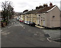
1
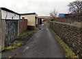
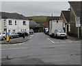
Lane on the NE side of Coronation Terrace, Rhymney
Viewed from the King Edward Terrace end, at the edge of Penuel. http://www.geograph.org.uk/photo/3871497
Image: © Jaggery
Taken: 17 Jan 2014
0.05 miles
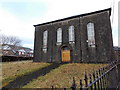
2
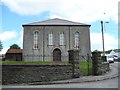
Penuel Baptist Chapel, Rhymney
The plaque above the centre windows says - PENUEL / BAPTIST CHAPEL / 1838 REBUILT 1859
Image: © Robin Drayton
Taken: 18 Jul 2007
0.08 miles
3
Tŷ Gwyn, Rhymney
Recently-built house in Coronation Terrace. The literal meaning of Tŷ Gwyn is white house, which doesn't apply here. However, gwyn in Welsh also means blessed and as a noun can mean something that is desirable or brings happiness, so an excellent name for a house!
Image: © Jaggery
Taken: 17 Jan 2014
0.08 miles
5
Queen's Crescent, Rhymney
Looking to the NW along the B4257 Queen's Crescent. The corner of Price Street https://www.geograph.org.uk/photo/5999348 is on the right.
Image: © Jaggery
Taken: 12 Dec 2018
0.08 miles
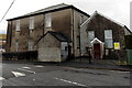
6
Penuel Baptist Chapel, Rhymney
Viewed across King Edward Terrace in January 2014. The exterior has weathered considerably since this view http://www.geograph.org.uk/photo/498824 taken in July 2007.
Image: © Jaggery
Taken: 17 Jan 2014
0.09 miles
7
Rhymney United Welsh Chapel, Rhymney
Viewed across King Edward Terrace. The yellow nameboard shows Rhymney United Welsh Chapel.
The large building on the left is Penuel Baptist chapel. http://www.geograph.org.uk/photo/3871497
Image: © Jaggery
Taken: 17 Jan 2014
0.10 miles
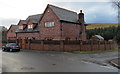
8
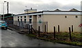
Oaklands Day Centre, Rhymney
Located in Oakland Terrace, near Upper Rhymney Primary School. http://www.geograph.org.uk/photo/3939923
The Caerphilly County Borough Council day centre provides a range of services (including respite breaks) for adults of any age with learning disabilities, physical disabilities or mental health problems.
Image: © Jaggery
Taken: 17 Jan 2014
0.11 miles
9
King Edward Terrace, Rhymney
Looking west along King Edward Terrace across the B4257 from Kings Avenue.
The 30mph speed limit drops to 20 on the approach to Upper Rhymney Primary School. https://www.geograph.org.uk/photo/3939923
Image: © Jaggery
Taken: 5 Apr 2019
0.12 miles
10
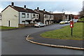
Coronation Terrace houses and a postbox, Rhymney
Coronation Terrace is part of the B4257.
Image: © Jaggery
Taken: 17 Jan 2014
0.12 miles