IMAGES TAKEN NEAR TO
Nursery Terrace, TREDEGAR, NP22 4QB
Introduction
This page details the photographs taken nearby to Nursery Terrace, NP22 4QB by members of the Geograph project.
The Geograph project started in 2005 with the aim of publishing, organising and preserving representative images for every square kilometre of Great Britain, Ireland and the Isle of Man.

There are currently over 7.5m images from over14,400 individuals and you can help contribute to the project by visiting https://www.geograph.org.uk
Image Map
Images are licensed for reuse under creativecommons.org/licenses/by-sa/2.0
Notes
- Clicking on the map will re-center to the selected point.
- The higher the marker number, the further away the image location is from the centre of the postcode.
Image Listing (85 Images Found)
Images are licensed for reuse under creativecommons.org/licenses/by-sa/2.0
Image
Details
Distance
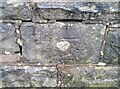
2
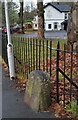
Boundary Stone
Boundary Stone with 'S 1818' carved on the front.
Image: © Adrian Dust
Taken: 5 Dec 2020
0.07 miles
3
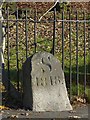
Sirhowy boundary stone
With S for Sirhowy and the date 1818, this stone was one of a number that were erected to mark the boundary of The Sirhowy Ironworks.
This followed a dispute between local ironmasters over a lease and instead of being associated with the Tredegar Ironworks, the Sirhowy Ironworks became linked with the Ebbw Vale ironworks in the next valley. The new Sirhowy owners placed these marker stones to show the boundaries of their property.
Image: © Robin Drayton
Taken: 22 Nov 2013
0.07 miles
4
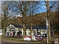
The Railway Tavern, Sirhowy
Sir Daniel Gooch, lived here during the 1830s.
He started work in the Tredegar Ironworks, initially making cores and then moulding tram wheels. Subsequently he joined the Great Western Railway eventually becoming Locomotive Superintendent under Isambard Brunel. Later, he became Chairman of the Great Western Company, overseeing such projects as the Great Western steamship and the construction of the Severn Tunnel.
There is an old boundary stone http://www.geograph.org.uk/photo/3756848 at the bottom right of the picture.
Image: © Robin Drayton
Taken: 22 Nov 2013
0.09 miles
5
The Railway Tavern and autumn leaves, Sirhowy
For another view and information on the tavern see this http://www.geograph.org.uk/photo/3756833 .
Image: © Robin Drayton
Taken: 22 Nov 2013
0.09 miles
7
Ordnance Survey Cut Mark
This OS cut mark can be found on the NE parapet of the bridge on Beaufort Road. It marks a point 313.786m above mean sea level.
Image: © Adrian Dust
Taken: 5 Dec 2020
0.10 miles
8
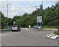
Direction sign facing the A4048, Tredegar
On the approach to Town Centre Roundabout.
Image: © Jaggery
Taken: 1 Jun 2017
0.10 miles
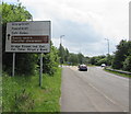
9
North along the A4048, Tredegar
Signs on the right show ahead along the A4048 for Merthyr Tydfil and Abergavenny.
Nearer locations ahead are Sirhowy, Ashvale, Dukestown Industrial Estates.
Image: © Jaggery
Taken: 1 Jun 2017
0.10 miles
10
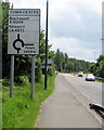
Directions sign on the approach to Town Centre Roundabout, Tredegar
Alongside the A4048.
Image: © Jaggery
Taken: 1 Jun 2017
0.10 miles