1
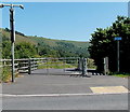
Houses at the southern edge of Tredegar
Viewed across Pochin Crescent near Heathfield Roundabout. http://www.geograph.org.uk/photo/3542960
The detached house centre left was built c2009.
Image: © Jaggery
Taken: 6 Jul 2013
0.01 miles
2
Southern edge of Tredegar
A view along Pochin Crescent in the Peacehaven area of Tredegar.
Heathfield Roundabout and the A4048 http://www.geograph.org.uk/photo/3542960 are behind the camera.
The National Speed Limit on this side of the signs reduces to 30mph ahead.
The red and blue circular signs showing End mark the end of a no stopping (clearway) zone.
Image: © Jaggery
Taken: 6 Jul 2013
0.04 miles
3
SW end of Pochin Crescent, Tredegar
Looking towards the A4048 at Heathfield Roundabout. http://www.geograph.org.uk/photo/3542960
Image: © Jaggery
Taken: 6 Jul 2013
0.04 miles
4
Pochin Crescent entrance to a cycleway and footpath, Peacehaven, Tredegar
Access to the combined cycle route and footpath http://www.geograph.org.uk/photo/3543046 is on the right. The gate giving access to the road alongside the path is locked.
Image: © Jaggery
Taken: 6 Jul 2013
0.04 miles
5
Sirhowy River
Looking down from the river bridge on the road just off the A4048 roundabout which leads to Ponchin Crescent.
Image: © Sally Lloyd
Taken: 22 Jul 2007
0.06 miles
6
Heathfield Roundabout, Tredegar
Viewed from Pochin Crescent looking towards the A4048 at the southern edge of Tredegar.
Image: © Jaggery
Taken: 6 Jul 2013
0.06 miles
7
Cycle route south of Peacehaven, Tredegar
The combined cycle route and footpath, centre right between the posts and wire fencing, heads south away from Pochin Crescent. Access to the road on the left is blocked by a locked gate behind the camera at the edge of Pochin Crescent. http://www.geograph.org.uk/photo/3543058
Image: © Jaggery
Taken: 6 Jul 2013
0.06 miles
8
Sirhowy River looking upriver, Peacehaven
Image: © Robin Drayton
Taken: 18 Feb 2009
0.07 miles
9
Brompton Place, Tredegar
Viewed across Pochin Crescent.
Image: © Jaggery
Taken: 6 Jul 2013
0.07 miles
10
Iron slag and gorse
This is one of a pair of lumps of iron slag about3 metres high on the open ground south of Peacehaven and just off the new Sirhowy valley cycleway
Image: © nantcoly
Taken: 29 Apr 2008
0.07 miles


