IMAGES TAKEN NEAR TO
Railway Terrace, TREDEGAR, NP22 4HA
Introduction
This page details the photographs taken nearby to Railway Terrace, NP22 4HA by members of the Geograph project.
The Geograph project started in 2005 with the aim of publishing, organising and preserving representative images for every square kilometre of Great Britain, Ireland and the Isle of Man.

There are currently over 7.5m images from over14,400 individuals and you can help contribute to the project by visiting https://www.geograph.org.uk
Image Map
Images are licensed for reuse under creativecommons.org/licenses/by-sa/2.0
Notes
- Clicking on the map will re-center to the selected point.
- The higher the marker number, the further away the image location is from the centre of the postcode.
Image Listing (23 Images Found)
Images are licensed for reuse under creativecommons.org/licenses/by-sa/2.0
Image
Details
Distance
1
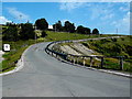
Road to Trefil Quarries
Viewed across Trefil Road. The quarries http://www.geograph.org.uk/photo/760558 are on bleak moorland.
Image: © Jaggery
Taken: 22 Aug 2013
0.09 miles
2
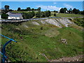
Side view of the road to Trefil Quarries
Viewed from Trefil Road.
Image: © Jaggery
Taken: 22 Aug 2013
0.09 miles
3
Trefil
Cerddwyr yn cyrraedd pentre Trefil gyda chyn Capel Horeb, addoldy'r Annibynnwyr, yn y pellter.
Walkers arriving at Trefil with the former Horeb Welsh Independent Chapel in the distance.
Image: © Alan Richards
Taken: 6 Jun 2010
0.09 miles
4
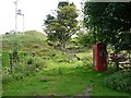
An out of the way telephone box, Trefil
Situated on the left, off the road through Trefil http://www.geograph.org.uk/photo/3137067 .
Image: © Robin Drayton
Taken: 6 Sep 2012
0.11 miles
5
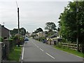
Entering Trefil from the north
The road is on the route of Hall’s Trefil Tramroad which opened in 1806 and connected the quarries at Trefil with the Rhymney ironworks.
Image: © Robin Drayton
Taken: 6 Sep 2012
0.12 miles
6
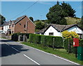
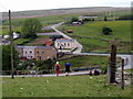
Postbox and houses in Trefil
Alongside Trefil Road.
Image: © Jaggery
Taken: 22 Aug 2013
0.13 miles
7
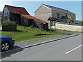
Corrugated farm building and a former chapel in Trefil
Viewed across Trefil Road. On the right, the former Horeb Independent Chapel is now in residential use.
Image: © Jaggery
Taken: 22 Aug 2013
0.14 miles
8
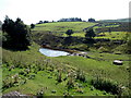
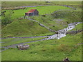
Pipeline and pond below Trefil Road, Trefil
Two youngsters are sitting on the pipeline at the northern edge of the pond.
Image: © Jaggery
Taken: 22 Aug 2013
0.14 miles
10
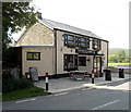
Tafarn Tŷ Uchaf, Trefil
The village pub is located alongside Trefil Road at about 410 metres (c 1,345 ft) above sea level.
On the name board, the pub's English name Top House is in smaller text below its Welsh name
Tafarn Tŷ Uchaf.
Image: © Jaggery
Taken: 22 Aug 2013
0.15 miles