IMAGES TAKEN NEAR TO
Troedrhiwgwair, TREDEGAR, NP22 4DD
Introduction
This page details the photographs taken nearby to Troedrhiwgwair, NP22 4DD by members of the Geograph project.
The Geograph project started in 2005 with the aim of publishing, organising and preserving representative images for every square kilometre of Great Britain, Ireland and the Isle of Man.

There are currently over 7.5m images from over14,400 individuals and you can help contribute to the project by visiting https://www.geograph.org.uk
Image Map
Images are licensed for reuse under creativecommons.org/licenses/by-sa/2.0
Notes
- Clicking on the map will re-center to the selected point.
- The higher the marker number, the further away the image location is from the centre of the postcode.
Image Listing (17 Images Found)
Images are licensed for reuse under creativecommons.org/licenses/by-sa/2.0
Image
Details
Distance
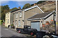
1
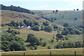
Troedrhiw-gwair, Sirhowy Valley
Houses viewed from across the Upper Sirhowy Valley; there is a disused quarry above the houses. Cefn Manmoel is on the skyline
Image: © M J Roscoe
Taken: 6 Jul 2017
0.02 miles
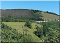
2
Troedrhiwgwair village
The remains of the evacuated village viewed from across the river on a clear autumn day. The two houses to the right can be seen in Image There is a belt of conifers on the skyline above the disused quarry.
Image: © M J Roscoe
Taken: 19 Oct 2018
0.04 miles
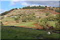
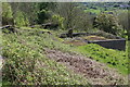
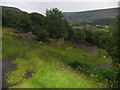
3
View of Troedrhiwgwair from Bedwellty Pit Tip.
There used to be 161 houses in Troedrhiwgwair, along with a school, a library, a pub, shops etc. http://web.ukonline.co.uk/b.gardner/tredegar/tredpage.html#troed .
However, after the Aberfan disaster, engineers were afraid that the hillside might collapse onto the houses. Because of movement in the mountain the school was closed down in the 1960s and most of the village was moved out in the 1970s to new houses at Peacehaven. Some residents refused to move and their houses can still be seen, with gaps in between where the other houses were removed. The river in the picture is the Sirhowy, which meanders down this part of the valley between the remains of coal tips.
Image: © Jessica Aidley
Taken: 22 Jul 2007
0.04 miles
4
The remaining houses in Troedrhiwgwair
Viewed across the Sirhowy Valley, Troedrhiwgwair was originally known as Himalaya Range. http://web.ukonline.co.uk/b.gardner/tredegar/troed.html
Image: © Robin Drayton
Taken: 4 Nov 2006
0.07 miles
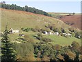
5
Houses at Troedrhiwgwair
Two of the few remaining houses in the village, most have been demolished for fear of land slides from the hillside immediately behind the houses.
Image: © M J Roscoe
Taken: 19 Oct 2018
0.11 miles
6
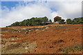
Conifers above Troedrhiwgwair
Belt of conifers above disused hillside quarry.
Image: © M J Roscoe
Taken: 19 Oct 2018
0.13 miles
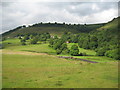
7
Across the Sirhowy valley towards Troedrhiwgwair
Viewed from the A4048 south of Tredegar.
Image: © Jaggery
Taken: 6 Jul 2013
0.13 miles
8
Remains of school, Troedrhiwgwair
Remaining retaining walls of the yard of the village school. The Victorian school closed in 1973 and in the 1980s were set alight as part of a BBC TV series set in the 1930s.
Image: © M J Roscoe
Taken: 27 May 2021
0.14 miles
9
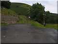
The end of the road
The end of the road and the turning point at the village of Troedrhiwgwair.
Image: © Nick Toulson
Taken: 19 Jul 2007
0.15 miles
10
The Old School
These are the remains of the old school in the village of Troedrhiwgwair. The school and the village featured in the TV programme 'The District Nurse' starring Nerys Hughes. See the text accompanying the picture of 'Troedrhiwgwair from Bedwellty Pits' for more information http://www.geograph.org.uk/photo/502809
Image: © Nick Toulson
Taken: 19 Jul 2007
0.16 miles