IMAGES TAKEN NEAR TO
Park View, TREDEGAR, NP22 3NZ
Introduction
This page details the photographs taken nearby to Park View, NP22 3NZ by members of the Geograph project.
The Geograph project started in 2005 with the aim of publishing, organising and preserving representative images for every square kilometre of Great Britain, Ireland and the Isle of Man.

There are currently over 7.5m images from over14,400 individuals and you can help contribute to the project by visiting https://www.geograph.org.uk
Image Map
Images are licensed for reuse under creativecommons.org/licenses/by-sa/2.0
Notes
- Clicking on the map will re-center to the selected point.
- The higher the marker number, the further away the image location is from the centre of the postcode.
Image Listing (200 Images Found)
Images are licensed for reuse under creativecommons.org/licenses/by-sa/2.0
Image
Details
Distance
1
View over Tredegar (2013)
Looking down Park Hill near Cefn Golau and over the town of Tredegar.
A similar view to one taken five years earlier http://www.geograph.org.uk/photo/723221 .
Obvious changes are that the canopy over the pumps of the former petrol station in the foreground has been removed, and a wind turbine has been constructed in the Rassau Industrial Estate in the distance http://www.geograph.org.uk/photo/2872372 .
Also visible are the mounds of disturbed earth on the moorland beyond the houses and trees. These are the result of the current construction work along the A465 http://www.geograph.org.uk/photo/3652909 .
An imminent change will be the construction of the Circuit of Wales motor racing circuit that will eat up 830 acres of the distant moorland behind the Rassau Industrial Estate.
Image: © Robin Drayton
Taken: 10 Oct 2013
0.04 miles
2
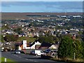
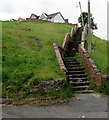
From Park Hill towards Pencoed houses, Tredegar
A side road from the B4256 Park Hill ascends towards a long flight of steps http://www.geograph.org.uk/photo/5401157
up to the eastern end of the street named Pencoed.
Image: © Jaggery
Taken: 23 May 2017
0.04 miles
3
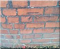
Ordnance Survey Cut Mark
This OS cut mark can be found on the wall of No45 Park View. It marks a point 345.345m above mean sea level.
Image: © Adrian Dust
Taken: 27 Aug 2018
0.04 miles
4
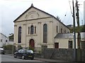
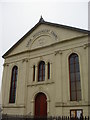
Saron Independent Chapel
Saron Independent (Congregational) Chapel together with the attached schoolroom is a Grade II listed building. The existing building is dated 1858, although the original chapel was built in 1819. Front walls and railings have a separate Grade II listing.
Saron (Sharon) is a biblical place name as recorded in Song of Solomon 2:1 "I am the rose of Sharon".
Image: © Robin Drayton
Taken: 27 Sep 2007
0.05 miles
5
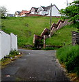
Long flight of steps to Pencoed, Tredegar
Ascending to the eastern end of the street named Pencoed.
Image: © Jaggery
Taken: 23 May 2017
0.06 miles
7
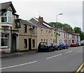
West side of Park Row, Tredegar
Viewed across the B4256 Park Row.
Image: © Jaggery
Taken: 23 May 2017
0.07 miles
8
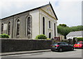
Saron Congregational Church, Park Row, Tredegar
In May 2017, the name on the church information board behind the car is Saron Congregational Church.
The pediment http://www.geograph.org.uk/photo/5405191 shows SARON INDEPENDENT CHAPEL BUILT 1858.
The building was Grade II listed in 1999.
Image: © Jaggery
Taken: 23 May 2017
0.07 miles
9
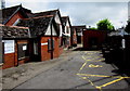
Yellow marked area, Tredegar General Hospital
The area is reserved for the vehicles of Blue Badge holders.
The bilingual name sign on the wall shows Tredegar General Hospital and its Welsh equivalent.
Image: © Jaggery
Taken: 23 May 2017
0.07 miles
10
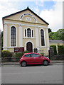
East side of Saron Congregational Church, Park Row, Tredegar
The pediment shows SARON INDEPENDENT CHAPEL BUILT 1858.
In May 2017, the name on the church information board
behind the car is Saron Congregational Church.
The building was Grade II listed in 1999.
http://www.geograph.org.uk/photo/5405184 to a side view.
Image: © Jaggery
Taken: 23 May 2017
0.07 miles