IMAGES TAKEN NEAR TO
Park Hill, TREDEGAR, NP22 3NN
Introduction
This page details the photographs taken nearby to Park Hill, NP22 3NN by members of the Geograph project.
The Geograph project started in 2005 with the aim of publishing, organising and preserving representative images for every square kilometre of Great Britain, Ireland and the Isle of Man.

There are currently over 7.5m images from over14,400 individuals and you can help contribute to the project by visiting https://www.geograph.org.uk
Image Map
Images are licensed for reuse under creativecommons.org/licenses/by-sa/2.0
Notes
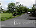
- Clicking on the map will re-center to the selected point.
- The higher the marker number, the further away the image location is from the centre of the postcode.
Image Listing (144 Images Found)
Images are licensed for reuse under creativecommons.org/licenses/by-sa/2.0
Image
Details
Distance
1
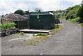
Park Hill electricity substation, Tredegar
The dark green cabinet is a Western Power Distribution electricity substation, identifier PARK HILL TREDEGAR S/S No. 55-1452. It is located alongside a side road above the B4256 Park Hill.
Image: © Jaggery
Taken: 23 May 2017
0.02 miles
2
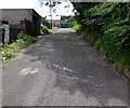
Side road above the B4256 Park Hill, Tredegar
The dark green object in the distance is this http://www.geograph.org.uk/photo/5401132 Western Power Distribution electricity substation.
Image: © Jaggery
Taken: 23 May 2017
0.02 miles
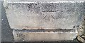
3
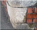
Ordnance Survey Cut Mark
This OS cut mark can be found on the wall of The Bush, Park Hill. It marks a point 326.941m above mean sea level.
Image: © Adrian Dust
Taken: 27 Aug 2018
0.04 miles
4
Tredegar Rugby Football Club headquarters, Park Hill
Opposite to Image the headquarters of another Tredegar rugby club.
Image: © Robin Drayton
Taken: 18 Feb 2009
0.04 miles
5
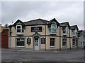
Bush hotel, Park Row, Tredegar
The home of Tredegar Ironsides Rugby Football Club.
Image: © Robin Drayton
Taken: 18 Feb 2009
0.04 miles
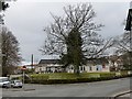
6
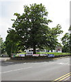
Dominant tree on a Tredegar corner
The tree on the corner of Stable Lane and Park Hill partly
hides the Tredegar Rugby Club clubhouse 20 metres behind it.
Image: © Jaggery
Taken: 23 May 2017
0.04 miles
7
Ordnance Survey Cut Mark
This OS cut mark can be found at the junction of Park Hill & Inkerman Terrace. It marks a point 335.713m above mean sea level.
Image: © Adrian Dust
Taken: 27 Aug 2018
0.05 miles
8
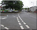
Junction of the B4256 and Stable Lane, Tredegar
Stable Lane is on the left. This junction is where B4256 Park Row on the camera side becomes the B4256 Park Hill ahead.
Image: © Jaggery
Taken: 23 May 2017
0.05 miles
9
Parkville, Tredegar
The northwest end of the road named Parkville viewed across the B4256 Park Hill.
The notice at the edge of the field on the left shows NO GOLF ALLOWED.
Image: © Jaggery
Taken: 23 May 2017
0.05 miles
10
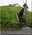
Long flight of steps to Pencoed, Tredegar
Ascending to the eastern end of the street named Pencoed.
Image: © Jaggery
Taken: 23 May 2017
0.05 miles