1
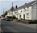
Brecon Terrace, Tafarnaubach
Houses on the north side of Merthyr Road which here is 375 metres (1,230 feet) above mean sea level.
Image: © Jaggery
Taken: 15 Apr 2019
0.02 miles
2
Speed camera warning sign in Tafarnaubach
On a Merthyr Road lamppost.
Image: © Jaggery
Taken: 15 Apr 2019
0.02 miles
3
Merthyr Road houses, Tafarnaubach
On the north side of Merthyr Road which here is 375 metres (1,230 ft) above mean sea level.
Image: © Jaggery
Taken: 15 Apr 2019
0.05 miles
4
Welfare Hall, Merthyr Road, Tafarnaubach
Coflein records that Tafarnaubach & Princetown Miners' Welfare Hall opened in 1937 as a branch of the Tredegar Workmen's Institute. Funded through a grant from the Miners' Welfare Fund, the hall provided facilities typical of workmen's institutes of that period.
Image: © Jaggery
Taken: 15 Apr 2019
0.05 miles
5
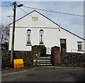
Siloam Baptist Chapel, Tafarnaubach
The plaque says SILOAM / CAPEL BEDYDDWYR / ADEILADWYD 1844 / AILADEILADWYD 1877 (Siloam Baptist Chapel, Built 1844, Rebuilt 1877).
Siloam is a Biblical place name.
Image: © Robin Drayton
Taken: 26 Sep 2007
0.06 miles
6
WSW along the A465, Tafarnaubach
Looking to the west southwest along the A465 Heads of the Valleys Road from the Merthyr Road bridge. https://www.geograph.org.uk/photo/6790143
Image: © Jaggery
Taken: 15 Apr 2019
0.07 miles
7
No Entry signs, Tafarnaubach
Facing Merthyr Road. Siloam Baptist Chapel https://www.geograph.org.uk/photo/6120504 is in the background.
Image: © Jaggery
Taken: 15 Apr 2019
0.07 miles
8
Welsh tablet on Siloam Baptist Chapel, Tafarnaubach
The tablet on the wall here https://www.geograph.org.uk/photo/6120504 records that the chapel was built in 1844, rebuilt in 1877.
Image: © Jaggery
Taken: 15 Apr 2019
0.08 miles
9
Victorian Siloam Baptist Chapel in Tafarnaubach
The Welsh tablet https://www.geograph.org.uk/photo/6120509 on the wall records that Siloam Baptist Chapel was built in 1844, rebuilt in 1877.
Image: © Jaggery
Taken: 15 Apr 2019
0.08 miles
10
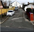
Private car park, Merthyr Road, Tafarnaubach
The notice on the left shows CLAIRTEX GWENT LTD. PRIVATE CAR PARK. ALL VEHICLES LEFT AT YOUR OWN RISK. CCTV IN OPERATION.
Image: © Jaggery
Taken: 15 Apr 2019
0.09 miles


