IMAGES TAKEN NEAR TO
Bettws Lane, NEWPORT, NP20 7ER
Introduction
This page details the photographs taken nearby to Bettws Lane, NP20 7ER by members of the Geograph project.
The Geograph project started in 2005 with the aim of publishing, organising and preserving representative images for every square kilometre of Great Britain, Ireland and the Isle of Man.

There are currently over 7.5m images from over14,400 individuals and you can help contribute to the project by visiting https://www.geograph.org.uk
Image Map
Images are licensed for reuse under creativecommons.org/licenses/by-sa/2.0
Notes
- Clicking on the map will re-center to the selected point.
- The higher the marker number, the further away the image location is from the centre of the postcode.
Image Listing (170 Images Found)
Images are licensed for reuse under creativecommons.org/licenses/by-sa/2.0
Image
Details
Distance
1

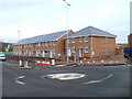
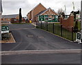
Foxglove Meadows, Newport
Located on the south side of Bettws Lane, Foxglove Meadows is a Barratt Homes development of 2- 3- 4- and 5-bedroom houses, occupying the site of the former Bettws High School, which was replaced by Newport High School http://www.geograph.org.uk/photo/1610526 which opened nearby in autumn 2009.
Seen here are two partly-built houses at the northern edge of the site.
Image: © Jaggery
Taken: 5 Sep 2010
0.01 miles
2
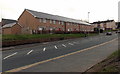
New housing, Bettws Lane, Newport
New housing at the NW edge of the former Bettws High School site, Bettws Lane. The site was redeveloped for housing when the school closed down on the opening of the adjacent newly-built Newport High School http://www.geograph.org.uk/photo/1610526 in 2009.
Here's how the site looked four months earlier. http://www.geograph.org.uk/photo/2052523
Image: © Jaggery
Taken: 6 Jan 2011
0.01 miles
3
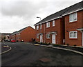
Recently-built housing, Bettws Lane, Newport
Built as part of the Barratt Homes Foxglove Meadows development. http://www.geograph.org.uk/photo/3332923
The view is looking towards the roundabout at the Monnow Way junction.
Image: © Jaggery
Taken: 15 Feb 2013
0.02 miles
4
West-east section of Clos Carno, Bettws, Newport
Clos Carno is an L-shaped cul-de-sac of recently-built houses.
Viewed from the southern end of the section oriented north-south. http://www.geograph.org.uk/photo/3332705
Image: © Jaggery
Taken: 15 Feb 2013
0.03 miles
5
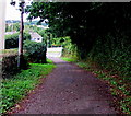
Path from Bettws Hill to Monnow Way, Newport
The path on the right here https://www.geograph.org.uk/photo/6208103 gives walkers and cyclists a shortcut to Monnow Way in the Bettws area of Newport.
Image: © Jaggery
Taken: 22 Aug 2018
0.03 miles
6
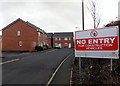
Entrance to Barratt Homes sales office, Foxglove Meadows, Bettws, Newport
Viewed from the street named Heol Senni, on the south side of Bettws Lane.
Foxglove Meadows is a Barratt development of 2- 3- and 4-bedroom terraced, semi-detached and detached houses located on former playing fields at the old Bettws High School, which was replaced in 2009 by the adjacent newly-built Newport High School. http://www.geograph.org.uk/photo/1610526
House building began here in 2010,. and was still in progress at the February 2013 date of this view. Many of the completed houses have been bought and are occupied.
Image: © Jaggery
Taken: 15 Feb 2013
0.03 miles
7
Clos Carno, Bettws, Newport
Clos Carno is an L-shaped cul-de-sac of recently-built houses.
Viewed from the edge of the roundabout at the Monnow Way / Bettws Lane roundabout.
This is the part of Clos Carno oriented north-south. http://www.geograph.org.uk/photo/3332713 to the east-west part around the corner ahead.
Image: © Jaggery
Taken: 15 Feb 2013
0.04 miles
8
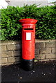
Queen Elizabeth II pillarbox in Bettws, Newport
On the east side of Monnow Way, near the corner of Bettws Close. http://www.geograph.org.uk/photo/4783717
Image: © Jaggery
Taken: 5 Jan 2016
0.04 miles
9
Monnow Way pillarbox, Bettws, Newport
On the east side of Monnow Way, near the corner of Bettws Close. The pillarbox is modern Elizabethan. http://www.geograph.org.uk/photo/4783709
Image: © Jaggery
Taken: 5 Jan 2016
0.04 miles
10
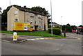
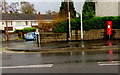
Yellow Dragon vehicle, Monnow Way, Bettws, Newport
In August 2018 text on the side of the vehicle includes TAP THE DRAGON TAXI APP TO BOOK.
Image: © Jaggery
Taken: 22 Aug 2018
0.04 miles