IMAGES TAKEN NEAR TO
Livale Road, NEWPORT, NP20 7DF
Introduction
This page details the photographs taken nearby to Livale Road, NP20 7DF by members of the Geograph project.
The Geograph project started in 2005 with the aim of publishing, organising and preserving representative images for every square kilometre of Great Britain, Ireland and the Isle of Man.

There are currently over 7.5m images from over14,400 individuals and you can help contribute to the project by visiting https://www.geograph.org.uk
Image Map
Images are licensed for reuse under creativecommons.org/licenses/by-sa/2.0
Notes
- Clicking on the map will re-center to the selected point.
- The higher the marker number, the further away the image location is from the centre of the postcode.
Image Listing (148 Images Found)
Images are licensed for reuse under creativecommons.org/licenses/by-sa/2.0
Image
Details
Distance
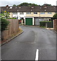
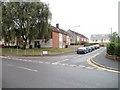
1
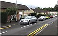
On-street parking, Livale Road, Bettws, Newport
Beyond the corner of Monnow Way where double yellow lines on both sides indicate no parking at any time.
Image: © Jaggery
Taken: 20 Aug 2018
0.01 miles
2

Warning sign - Patrol, Monnow Way, Bettws, Newport
Facing eastbound traffic on the approach to Millbrook Primary School.
Image: © Jaggery
Taken: 20 Aug 2018
0.03 miles
3
Livale Court, Bettws, Newport
Located between Livale Road and Rocky's Park (behind the camera).
Image: © Jaggery
Taken: 20 Aug 2018
0.03 miles
4
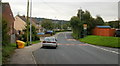
Pen-twyn Lane, Bettws, Newport
Heading towards Millbrook Junior and Infants School.
Image: © Jaggery
Taken: 31 Aug 2009
0.03 miles
5
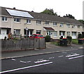
Parking space reserved for the vehicle of a Blue Badge holder, Monnow Way, Bettws, Newport
Painted on the road surface are DISABLED and its Welsh equivalent ANABL.
Image: © Jaggery
Taken: 20 Aug 2018
0.04 miles
6
Side road south of Monnow Way, Bettws, Newport
Towards houses in Livale Court.
Image: © Jaggery
Taken: 20 Aug 2018
0.05 miles
7
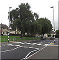
Zebra crossing, Monnow Way, Bettws, Newport
With a Belisha beacon and a street light on the same pole.
Image: © Jaggery
Taken: 20 Aug 2018
0.05 miles
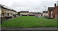
8
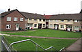
Houses on two sides of a rectangle, Bettws, Newport
Viewed from a Monnow Way bus stop.
Image: © Jaggery
Taken: 20 Aug 2018
0.06 miles
9
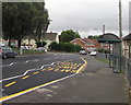
Monnow Way bus stop and shelter, Bettws, Newport
One of many bus stops on Monnow Way which extends for about 4km around the Bettws Estate.
This one is near Parret Road and Parret Close.
Image: © Jaggery
Taken: 20 Aug 2018
0.06 miles
10
Parret Close, Bettws, Newport
Viewed across Monnow Way. Parret Close leads to Tees Close and Meon Close.
Most streets in Bettws are named after rivers. The choice of names is interesting.
Doubtless many of the local residents (and also the occasional passing Geographer)
would not know even a rough location for some of river names used. For example, Meon was unknown to me when I took the photo. It is a fairly short river (21 miles or 38 kilometres) in Hampshire. http://www.geograph.org.uk/photo/1998625 The contributor of that photo stated "It is hardly big enough to qualify as a river".
Image: © Jaggery
Taken: 5 Sep 2010
0.07 miles