IMAGES TAKEN NEAR TO
Monnow Way, NEWPORT, NP20 7BQ
Introduction
This page details the photographs taken nearby to Monnow Way, NP20 7BQ by members of the Geograph project.
The Geograph project started in 2005 with the aim of publishing, organising and preserving representative images for every square kilometre of Great Britain, Ireland and the Isle of Man.

There are currently over 7.5m images from over14,400 individuals and you can help contribute to the project by visiting https://www.geograph.org.uk
Image Map
Images are licensed for reuse under creativecommons.org/licenses/by-sa/2.0
Notes
- Clicking on the map will re-center to the selected point.
- The higher the marker number, the further away the image location is from the centre of the postcode.
Image Listing (185 Images Found)
Images are licensed for reuse under creativecommons.org/licenses/by-sa/2.0
Image
Details
Distance
1
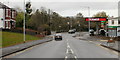
Monnow Way, Bettws, Newport
Monnow Way is the main road around the Bettws estate. It forms a loop around the estate : the two ends of the loop meet at the junction with Bettws Lane. This view is of the "high-numbered" (houses) end of Monnow Way, heading north away from Bettws Lane. The turning for the Merry Miller pub http://www.geograph.org.uk/photo/1572669 is on the left, opposite Texaco.
Image: © Jaggery
Taken: 7 Nov 2009
0.03 miles
2
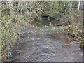
Malpas Brook, Bettws
Malpas Brook flowing away from the Monnow Way bridge. From here, the Brook takes a meandering course towards Crindau Pill and the River Usk.
Image: © Jaggery
Taken: 7 Nov 2009
0.03 miles
3
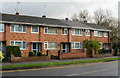
High numbers (odd) , Monnow Way, Bettws
The highest odd-numbered house on Monnow Way, number 719, is part of this block of houses.
Image: © Jaggery
Taken: 7 Nov 2009
0.03 miles
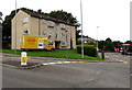
4
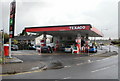
Texaco, Bettws, Newport
Located on Monnow Way, near the Bettws Lane junction. At the rear of the premises is a Londis Express store.
Image: © Jaggery
Taken: 7 Nov 2009
0.03 miles
5
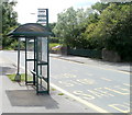
Wrong bus stop sign, Monnow Way, Newport
The sign on Monnow Way, Bettws claims that this is the Tregwylim Close stop, and shows five bus route numbers, none of which serve this area. A Google Earth street view taken some time earlier shows a tatty old shelter, so it looks like when this newer one was removed from Tregwilym (note the correct spelling) Close in Rogerstone, several kilometres away, and transplanted here, no-one bothered to replace the sign!
Image: © Jaggery
Taken: 9 Jun 2011
0.03 miles
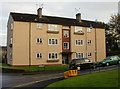
6
Three-storey flats, Monnow Way, Bettws, Newport
Located near Bettws Close and Bettws Lane.
Image: © Jaggery
Taken: 9 Feb 2018
0.04 miles
7
Yellow Dragon vehicle, Monnow Way, Bettws, Newport
In August 2018 text on the side of the vehicle includes TAP THE DRAGON TAXI APP TO BOOK.
Image: © Jaggery
Taken: 22 Aug 2018
0.04 miles
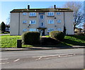
8
Bettws Hill flats, Newport
Bettws Hill side of flats on the corner of Monnow Way in the Bettws area of Newport.
Image: © Jaggery
Taken: 22 Aug 2018
0.04 miles
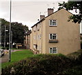
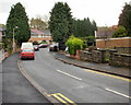
9
Bettws Hill, Newport
Housing at the bottom of Bettws Hill, on the corner of Monnow Way.
Image: © Jaggery
Taken: 7 Nov 2009
0.04 miles
10
Bettws Close, Newport
Viewed from Monnow Way.
Image: © Jaggery
Taken: 7 Nov 2009
0.04 miles