IMAGES TAKEN NEAR TO
Malpas Road, NEWPORT, NP20 6QY
Introduction
This page details the photographs taken nearby to Malpas Road, NP20 6QY by members of the Geograph project.
The Geograph project started in 2005 with the aim of publishing, organising and preserving representative images for every square kilometre of Great Britain, Ireland and the Isle of Man.

There are currently over 7.5m images from over14,400 individuals and you can help contribute to the project by visiting https://www.geograph.org.uk
Image Map
Images are licensed for reuse under creativecommons.org/licenses/by-sa/2.0
Notes
- Clicking on the map will re-center to the selected point.
- The higher the marker number, the further away the image location is from the centre of the postcode.
Image Listing (325 Images Found)
Images are licensed for reuse under creativecommons.org/licenses/by-sa/2.0
Image
Details
Distance
1
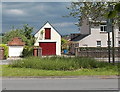
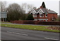
Former barn, Malpas Road, Newport
The building with doors on the ground floor and upper floor was formerly a barn, decades ago,
when this northern part of Malpas Road was rural, containing a few farms.
Image: © Jaggery
Taken: 30 May 2013
0.01 miles
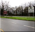
2
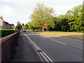
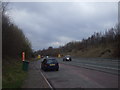
South along the A4051 into the city of Newport
Here named Malpas Road, the A4051 from Cwmbran approaches the Welcome to Newport sign. https://www.geograph.org.uk/photo/6159434
Maps shows that the actual Newport/Cwmbran boundary is a few metres behind the camera.
Image: © Jaggery
Taken: 22 May 2019
0.01 miles
3
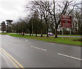
Welcome to the City of Newport
The A4051 from Torfaen County Borough reaches the northern boundary of the City of Newport.
Newport's population on the day of the 2011 Census was 145,700. The brown sign seen here in early January 2016 has replaced the green one http://www.geograph.org.uk/photo/1444532 photographed in August 2009.
Image: © Jaggery
Taken: 8 Jan 2016
0.02 miles
4
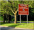
Welcome to the City of Newport, Malpas Road, Newport
Located here. https://www.geograph.org.uk/photo/6159426 The text is also in Welsh.
Image: © Jaggery
Taken: 22 May 2019
0.02 miles
6
Northernmost houses in Malpas Road, Newport
Malpas Road extends for 3½ km, from the edge of the city centre in the south to the northern boundary of Newport here at the southern edge of Torfaen.
Image: © Jaggery
Taken: 28 Feb 2015
0.02 miles
7
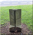
Torfaen/Newport boundary stone, Malpas Road
The stone was installed in 1996, the year in which Torfaen became a county borough.
It is located at the western edge of the A4051 Malpas Road, near the accurately-placed Torfaen http://www.geograph.org.uk/photo/1444521 and Newport http://www.geograph.org.uk/photo/1594757 boundary signs.
Image: © Jaggery
Taken: 30 May 2013
0.02 miles
8
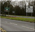
Traffic signal and speed cameras sign on the northern approach to Newport
Viewed from Torfaen looking across the A4051 Malpas Road.
The City of Newport northern boundary sign is on the left.
Image: © Jaggery
Taken: 28 Feb 2015
0.02 miles
9
Traffic signal and speed cameras sign on the northern approach to Newport
Viewed from Torfaen looking across the A4051 Malpas Road.
The City of Newport northern boundary sign http://www.geograph.org.uk/photo/4786713 is on the left.
Image: © Jaggery
Taken: 8 Jan 2016
0.02 miles
10
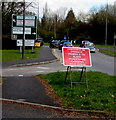
Red temporary sign near the northern end of Malpas Road, Newport
In mid April 2016, the temporary sign faces northbound traffic on the A4051 Malpas Road on the approach to the Woodlands Roundabout. The sign shows PEDESTRIANS CROSSING ROAD AHEAD and the Welsh equivalent.
Image: © Jaggery
Taken: 16 Apr 2016
0.03 miles