IMAGES TAKEN NEAR TO
Graig Park Circle, NEWPORT, NP20 6HF
Introduction
This page details the photographs taken nearby to Graig Park Circle, NP20 6HF by members of the Geograph project.
The Geograph project started in 2005 with the aim of publishing, organising and preserving representative images for every square kilometre of Great Britain, Ireland and the Isle of Man.

There are currently over 7.5m images from over14,400 individuals and you can help contribute to the project by visiting https://www.geograph.org.uk
Image Map
Images are licensed for reuse under creativecommons.org/licenses/by-sa/2.0
Notes
- Clicking on the map will re-center to the selected point.
- The higher the marker number, the further away the image location is from the centre of the postcode.
Image Listing (1438 Images Found)
Images are licensed for reuse under creativecommons.org/licenses/by-sa/2.0
Image
Details
Distance
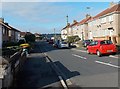
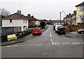
1
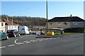
The two arms of Graig Park Circle, Malpas, Newport
Viewed from the straight north end of Graig Park Circle. Ahead, the southern part of the street is much more like a square than a circle. Houses in the Graig Park area, between Malpas Road and Graig Wood, were built c1930.
Image: © Jaggery
Taken: 10 Mar 2012
0.02 miles
2
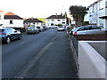
SSW along Graig Park Circle, Newport
You may well ask how a straight road can be part of a circle.
Maps show that the course of Graig Park Circle most
closely resembles a rectangle.
Image: © Jaggery
Taken: 20 May 2020
0.05 miles
3
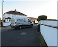
Innserve van, Graig Park Circle, Newport
Text on the side of van in May 2020 includes "Dispense solutions passionately delivered".
Image: © Jaggery
Taken: 20 May 2020
0.05 miles
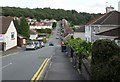
4
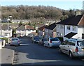
SE corner of Graig Park Circle, Malpas, Newport
"Circle" is not the best choice of name for this residential road, the course of which is much closer to a rectangle than a circle. Ahead is a 90-degree bend in the road.
Houses in the Graig Park area, between Malpas Road and Graig Wood, were built c1930.
In the background are houses in Graig Wood Close.
Image: © Jaggery
Taken: 10 Mar 2012
0.05 miles
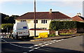
5
Graig Park Circle, Malpas, Newport
Looking south from the edge of this http://www.geograph.org.uk/photo/4072426 Western Power Distribution electricity substation on the corner of Graig Park Road. Houses in Graig Park, between Malpas Road and Graig Wood, were built c1930.
Image: © Jaggery
Taken: 15 Jul 2014
0.05 miles
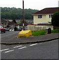
6
Yellow grit box, Graig Park Circle, Malpas, Newport
The contents of the box are used by council staff to treat the road surface in icy or snowy conditions. Winter conditions in this part of low-lying coastal South Wales are very variable. At one extreme, the winter of 2013-2014 was mild and with much rain, but little ice and no snow at all. At the other extreme, a 46-hour snowfall in January 1982 left a level 2 feet of snow hereabouts.
Image: © Jaggery
Taken: 15 Jul 2014
0.05 miles
7
Royal Mail drop box, Graig Park Circle, Newport
Alongside a yellow grit/salt box.
Image: © Jaggery
Taken: 1 May 2019
0.05 miles
8
Delaw van, Graig Park Circle, Newport
Delaw general builders are based in Western Valley Road, Rogerstone.
Image: © Jaggery
Taken: 20 May 2020
0.05 miles
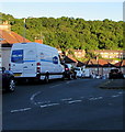
9
Straight part of Graig Park Circle, Malpas, Newport
Looking south across Graig Park Road.
A Western Power Distribution electricity substation is behind the yellow grit box. http://www.geograph.org.uk/photo/4072426
Image: © Jaggery
Taken: 1 Jan 2016
0.05 miles
10
Graig Park Road, Newport
The view from the Malpas Road end, looking along Graig Park Road towards Graig Wood. The car in the middle of the road is between the left turn for Graig Park Villas and the right turn for Graig Park Circle.
Image: © Jaggery
Taken: 1 Sep 2009
0.06 miles