IMAGES TAKEN NEAR TO
Brynglas Road, NEWPORT, NP20 5QX
Introduction
This page details the photographs taken nearby to Brynglas Road, NP20 5QX by members of the Geograph project.
The Geograph project started in 2005 with the aim of publishing, organising and preserving representative images for every square kilometre of Great Britain, Ireland and the Isle of Man.

There are currently over 7.5m images from over14,400 individuals and you can help contribute to the project by visiting https://www.geograph.org.uk
Image Map
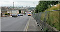
Images are licensed for reuse under creativecommons.org/licenses/by-sa/2.0
Notes
- Clicking on the map will re-center to the selected point.
- The higher the marker number, the further away the image location is from the centre of the postcode.
Image Listing (334 Images Found)
Images are licensed for reuse under creativecommons.org/licenses/by-sa/2.0
Image
Details
Distance
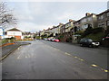
1
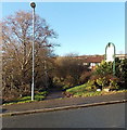
Path to Bryn Bevan houses, Newport
Viewed across Brynglas Road. The path leads to houses in the SW corner of Bryn Bevan. The course of the path is over the top of the M4 motorway Brynglas Tunnels near their western portals.
Image: © Jaggery
Taken: 28 Dec 2013
0.00 miles
2
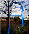
Aria Care Home name sign, Brynglas, Newport
On the Brynglas Road side of Aria residential care home http://www.geograph.org.uk/photo/4301372 at 147 Bryn Bevan,
in a converted building which was previously Newport Lodge Hotel.
Image: © Jaggery
Taken: 5 Jan 2016
0.01 miles
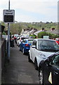
3
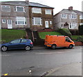
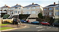
Two flights of steps behind two vehicles, Brynglas Road, Newport
These houses on the east side of Brynglas Road are set above road level, accessed by about fifteen steps.
Image: © Jaggery
Taken: 5 Jan 2016
0.02 miles
4
Shelterless bus stop, Brynglas Road, Newport
Near the corner of Bryn Bevan and Aria Care Home at 147 Bryn Bevan. https://www.geograph.org.uk/photo/6444546
Image: © Jaggery
Taken: 13 Apr 2020
0.02 miles
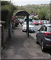
5
Two Brynglas Road bus stops, Newport
The wide stop on the left is for buses from the city centre. This route is served by NAT (New Adventure Travel) in January 2016. Newport Bus formerly provided the service.
Image: © Jaggery
Taken: 5 Jan 2016
0.02 miles
6
Brynglas Road bus stop and shelter near Bryn Bevan, Newport
No buses here and elsewhere in the city today, Easter Monday April 13th 2020.
Image: © Jaggery
Taken: 13 Apr 2020
0.02 miles
7
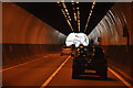
Newport : Brynglas Tunnels
The M4 Motorway heading eastbound as it passes through the Newport area.
Image: © Lewis Clarke
Taken: 11 Apr 2014
0.02 miles
8
Your speed indicator, Brynglas Road, Newport
Currently off, the display turns on to show the speed in green if an approaching vehicle is within the 30mph speed limit, or in red if over the speed limit.
Image: © Jaggery
Taken: 13 Apr 2020
0.03 miles
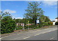
9
Brynglas Avenue, Newport
The view down Brynglas Avenue towards Redland Street. The fencing on the right protects a currently derelict area, the former site of prefabs.
Image: © Jaggery
Taken: 16 Aug 2009
0.03 miles
10
Elevated houses on Brynglas Road, Newport
Houses on much of the east side of Brynglas Road are based several metres above street level. This view is from Bryn Bevan.
Image: © Jaggery
Taken: 28 Dec 2009
0.03 miles