IMAGES TAKEN NEAR TO
Pant Road, NEWPORT, NP20 5PQ
Introduction
This page details the photographs taken nearby to Pant Road, NP20 5PQ by members of the Geograph project.
The Geograph project started in 2005 with the aim of publishing, organising and preserving representative images for every square kilometre of Great Britain, Ireland and the Isle of Man.

There are currently over 7.5m images from over14,400 individuals and you can help contribute to the project by visiting https://www.geograph.org.uk
Image Map
Images are licensed for reuse under creativecommons.org/licenses/by-sa/2.0
Notes
- Clicking on the map will re-center to the selected point.
- The higher the marker number, the further away the image location is from the centre of the postcode.
Image Listing (645 Images Found)
Images are licensed for reuse under creativecommons.org/licenses/by-sa/2.0
Image
Details
Distance
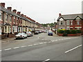
1
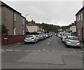
On-street parking, Pant Road, Newport
From Malpas Road, Pant Road leads to Pant Lane, Malpas Lane and Ross Street.
In the distance, Pant Road ends near the edge of the M4 motorway.
Pant is Welsh for hollow or valley.
Image: © Jaggery
Taken: 12 Jun 2020
0.01 miles
2
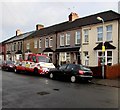
A2B Recovery vehicle, Pant Road, Crindau, Newport
A2B Recovery offers breakdown recovery, roadside assistance and nationwide transport services for the private motorist and commercial businesses.
Image: © Jaggery
Taken: 3 Jan 2016
0.02 miles
3
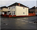
Corner of Pant Road and Ross Street, Crindau, Newport
Viewed across Pant Road.
Image: © Jaggery
Taken: 3 Jan 2016
0.02 miles
4
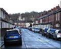
On-street parking, Ross Street, Newport
Looking towards Pant Road.
Image: © Jaggery
Taken: 17 Feb 2020
0.03 miles
5
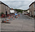
Pant Road roadworks August 2017, Crindau, Newport
Part of Pant Road is coned off and fenced off during Welsh Water roadworks in August 2017.
Image: © Jaggery
Taken: 19 Aug 2017
0.03 miles
6
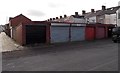
Pant Road lockup garages, Crindau, Newport
Between Malpas Lane on the left and Malpas Road, a few metres out of shot on the right.
Image: © Jaggery
Taken: 1 Oct 2014
0.03 miles
7
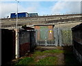
Pant Road electricity substation, Newport
Located at the NW end of Pant Lane, at the edge of the M4 motorway and a slip road to Junction 26 at Malpas Road. The identifier on the Western Power Distribution electricity substation is
PANT ROAD S/S No. 53-2505. Pant Road is 40 metres behind the camera.
Image: © Jaggery
Taken: 1 Oct 2014
0.03 miles
8
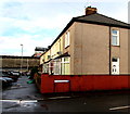
Corner of Malpas Road and Pant Road, Newport
A 1960 street map shows this corner alongside the A4051 Malpas Road. After the A4051 in this area was realigned during the construction of M4 motorway junction 26 in the late 1960s, this part of Malpas Road became a dead-end backwater. The wall at the edge of the motorway is in the background.
Image: © Jaggery
Taken: 5 Jan 2016
0.04 miles
9
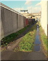
Pant Lane, Crindau, Newport
Viewed from Pant Road looking towards the M4 motorway and the top of an Ibis Budget hotel. http://www.geograph.org.uk/photo/3209163
Image: © Jaggery
Taken: 27 Jan 2013
0.04 miles
10
Ross Street, Newport
Looking towards Pant Road from the corner of Aston Crescent.
Image: © Jaggery
Taken: 30 Aug 2009
0.04 miles