IMAGES TAKEN NEAR TO
Malpas Road, NEWPORT, NP20 5PN
Introduction
This page details the photographs taken nearby to Malpas Road, NP20 5PN by members of the Geograph project.
The Geograph project started in 2005 with the aim of publishing, organising and preserving representative images for every square kilometre of Great Britain, Ireland and the Isle of Man.

There are currently over 7.5m images from over14,400 individuals and you can help contribute to the project by visiting https://www.geograph.org.uk
Image Map
Images are licensed for reuse under creativecommons.org/licenses/by-sa/2.0
Notes
- Clicking on the map will re-center to the selected point.
- The higher the marker number, the further away the image location is from the centre of the postcode.
Image Listing (652 Images Found)
Images are licensed for reuse under creativecommons.org/licenses/by-sa/2.0
Image
Details
Distance
1
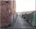
Looking along Malpas Lane towards Pant Road, Newport
The view from the corner of Jewell Lane. Just visible in the middle distance, in the centre of the photo, is the training tower of Malpas Fire Station. http://www.geograph.org.uk/photo/467335
Image: © Jaggery
Taken: 20 Feb 2010
0.01 miles
2
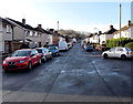
Pant Road, Crindau, Newport
Viewed from the turning semicircle at the far end of Pant Road, looking towards Malpas Road.
Pant is Welsh for hollow or valley.
Image: © Jaggery
Taken: 27 Jan 2013
0.01 miles
3
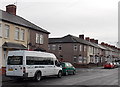
Jak's Minibus in Crindau, Newport
Parked in (Old) Malpas Road near the Pant Road corner.
Image: © Jaggery
Taken: 12 Dec 2014
0.01 miles
4

Temporary traffic lights in Crindau, Newport
Temporary traffic lights are in operation on the corner of
Malpas Road and Pant Road during Welsh Water roadworks in August 2017.
Image: © Jaggery
Taken: 19 Aug 2017
0.01 miles
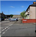
5
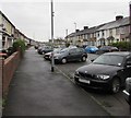
Malpas Road pavement, Crindau, Newport
This is the NW end of a 160 metres long part of Malpas Road, formerly a main road, which became a dead-end backwater when the course of the Malpas Road main road was realigned during the construction of M4 motorway junction 26 in the 1960s. A pedestrian underpass below the M4 is behind the camera.
Image: © Jaggery
Taken: 15 Nov 2015
0.01 miles
6
Junction of Pant Road and Malpas Road, Newport
From the right, Pant Road joins Malpas Road. The M4 motorway is on the flyover in the background.
Image: © Jaggery
Taken: 13 Apr 2020
0.01 miles
7
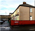
Corner of Malpas Road and Pant Road, Newport
A 1960 street map shows this corner alongside the A4051 Malpas Road. After the A4051 in this area was realigned during the construction of M4 motorway junction 26 in the late 1960s, this part of Malpas Road became a dead-end backwater. The wall at the edge of the motorway is in the background.
Image: © Jaggery
Taken: 5 Jan 2016
0.02 miles
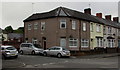
8

Corner of Malpas Road and Pant Road, Crindau, Newport
A dark green telecoms cabinet is behind the car on the Pant Road side of the corner.
Image: © Jaggery
Taken: 17 Feb 2020
0.02 miles
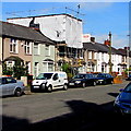
9
Junction of Malpas Road and Pant Road, Newport
The vehicles are parked in Pant Road. https://www.geograph.org.uk/photo/6505317
Image: © Jaggery
Taken: 12 Jun 2020
0.02 miles
10
Malpas Road house scaffolding and sheeting, Crindau, Newport
Viewed on August 23rd 2016.
Image: © Jaggery
Taken: 23 Aug 2016
0.02 miles