IMAGES TAKEN NEAR TO
Aragon Street, NEWPORT, NP20 5NN
Introduction
This page details the photographs taken nearby to Aragon Street, NP20 5NN by members of the Geograph project.
The Geograph project started in 2005 with the aim of publishing, organising and preserving representative images for every square kilometre of Great Britain, Ireland and the Isle of Man.

There are currently over 7.5m images from over14,400 individuals and you can help contribute to the project by visiting https://www.geograph.org.uk
Image Map
Images are licensed for reuse under creativecommons.org/licenses/by-sa/2.0
Notes
- Clicking on the map will re-center to the selected point.
- The higher the marker number, the further away the image location is from the centre of the postcode.
Image Listing (1081 Images Found)
Images are licensed for reuse under creativecommons.org/licenses/by-sa/2.0
Image
Details
Distance
1

Ferryman lorry in Aragon Street, Crindau, Newport
Based in Newbridge Road Industrial Estate, Pontllanfraith, South Wales,
Ferryman's business is transport, distribution and warehousing.
Image: © Jaggery
Taken: 9 May 2017
0.01 miles
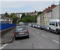
2
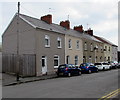
Aragon Street cars and houses, Crindau, Newport
Viewed from the corner of Ailesbury Street.
Image: © Jaggery
Taken: 9 May 2017
0.01 miles
3
Row of houses, Aragon Street, Newport
The path behind the railings leads to a Sainsbury's superstore.
Image: © Jaggery
Taken: 17 Jul 2018
0.01 miles
4
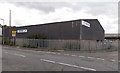
Edmundson Electrical, Crindau, Newport
Located in Albany Industrial Estate on the north side of Aragon Street, this is one of more than 250 Edmundson Electrical locations in the UK. Founded in 1801 by Joshua Edmundson, the company was one of the first suppliers of electricity. It is now a distributor of electrical equipment to trade and industry in the UK.
Image: © Jaggery
Taken: 14 Oct 2013
0.01 miles
5
Aragon Street towards Albany Street, Crindau, Newport
The houses are opposite the north side of Crindau Primary School.
Image: © Jaggery
Taken: 17 Jul 2018
0.02 miles
6
Yellow and white gas pipeline marker, Aragon Street, Newport
The Wales & West Utilities marker is near an underground gas pipeline.
It shows an 0800 (free) number to phone before excavating in this area or in an emergency.
All calls are recorded and may be monitored. Another phone number is shown for general pipeline enquiries.
Image: © Jaggery
Taken: 17 Jul 2018
0.02 miles
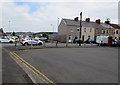
7
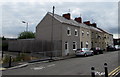
Aragon Street, Crindau, Newport
This part of Aragon Street is between Argyle Street and Ailesbury Street.
The blue railings are at the edge of Crindau Primary School.
Redland Street houses are on higher ground in the distance.
Image: © Jaggery
Taken: 9 May 2017
0.02 miles
8
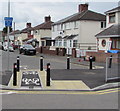
Cycle route 88, Ailesbury Street, Newport
National Cycle Network Route 88 is a proposed mainly coastal route from Newport to Margam Country Park via Cardiff and Bridgend. In July 2018, only short sections of the route are open. This section is in the Crindau area of Newport.
Image: © Jaggery
Taken: 17 Jul 2018
0.02 miles
9
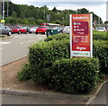
Sainsbury's, Argos and Lloyds Pharmacy names sign, Crindau, Newport
Facing the entrance from Aragon Street to the Sainsbury's superstore in the Crindau area of Newport.
Image: © Jaggery
Taken: 17 Jul 2018
0.02 miles
10
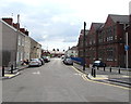
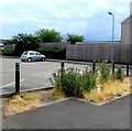
Turning area at the northern end of Ailesbury Street, Crindau, Newport
A row of concrete posts prevent motor vehicles wider than a motorbike entering Aragon Street from Ailesbury Street. Double yellow lines at the edge of the turning area indicate no parking at any time.
Image: © Jaggery
Taken: 9 May 2017
0.02 miles