IMAGES TAKEN NEAR TO
Barrack Hill, NEWPORT, NP20 5FR
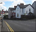
Introduction
This page details the photographs taken nearby to Barrack Hill, NP20 5FR by members of the Geograph project.
The Geograph project started in 2005 with the aim of publishing, organising and preserving representative images for every square kilometre of Great Britain, Ireland and the Isle of Man.

There are currently over 7.5m images from over14,400 individuals and you can help contribute to the project by visiting https://www.geograph.org.uk
Image Map
Images are licensed for reuse under creativecommons.org/licenses/by-sa/2.0
Notes
- Clicking on the map will re-center to the selected point.
- The higher the marker number, the further away the image location is from the centre of the postcode.
Image Listing (1158 Images Found)
Images are licensed for reuse under creativecommons.org/licenses/by-sa/2.0
Image
Details
Distance
1
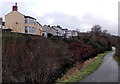
Canalside houses, Barrack Hill, Newport
The backs of these Barrack Hill houses are several metres above the disused Monmouthshire & Brecon Canal.
Image: © Jaggery
Taken: 19 Dec 2013
0.00 miles
2
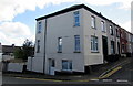
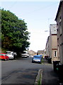
Corner of Barrack Hill and Power Street, Newport
Three storeys on the Barrack Hill side, two storeys on the Power Street side.
Image: © Jaggery
Taken: 8 Sep 2016
0.01 miles
3
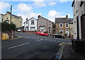
Junction of Power Street and Barrack Hill, Newport
Viewed from the northern end of Power Street.
Image: © Jaggery
Taken: 8 Sep 2016
0.01 miles
4
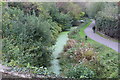
Southern end of the canal at Barrack Hill
Formerly, until 1930, the Mon & Brec Canal went into a tunnel beneath the camera on its way towards Newport Docks. The towpath is part of NCR 47.
Image: © M J Roscoe
Taken: 27 Oct 2018
0.02 miles
5
Power Street towards Barrack Hill, Newport
Looking past the Hopefield junction.
Image: © Jaggery
Taken: 8 Sep 2016
0.02 miles
6
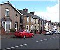
Barrack Hill houses, Newport
On the north side of Barrack Hill, between Power Street and Belvedere Terrace.
Image: © Jaggery
Taken: 8 Sep 2016
0.02 miles
7
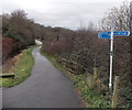
Cycle route 47 alongside a disused canal, Newport
Viewed from the corner of Barrack Hill. The towpath alongside the long disused Monmouthshire & Brecon Canal is now a footpath and also part of National Cycle Network route 47. Distances shown are 17 (miles) to Blaenavon via one branch of the canal and 7 to Crosskeys via the other branch.
The two branches diverge at Malpas junction ahead.
Image: © Jaggery
Taken: 19 Dec 2013
0.02 miles
8
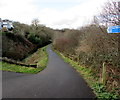
National Cycle Network Route 47 above the Mon & Brec, Crindau, Newport
Part of this https://www.geograph.org.uk/photo/5662694 National Cycle Network signpost is on the right. The cycle route here uses the towpath above a disused part of the Monmouthshire & Brecon Canal
Image: © Jaggery
Taken: 26 Jan 2018
0.03 miles
9
Warning sign - bend, Barrack Hill, Newport
The bend to the right shown on the sign appears wrong because Barrack Hill ahead bends to the left.
The sign is correct because most of the bend, out of shot ahead, is to the right.
Image: © Jaggery
Taken: 8 Sep 2016
0.03 miles
10
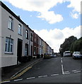
Power Street, Newport
The northern end of Power Street viewed across Barrack Hill.
Image: © Jaggery
Taken: 8 Sep 2016
0.03 miles