IMAGES TAKEN NEAR TO
Brickyard Lane, NEWPORT, NP20 5ES
Introduction
This page details the photographs taken nearby to Brickyard Lane, NP20 5ES by members of the Geograph project.
The Geograph project started in 2005 with the aim of publishing, organising and preserving representative images for every square kilometre of Great Britain, Ireland and the Isle of Man.

There are currently over 7.5m images from over14,400 individuals and you can help contribute to the project by visiting https://www.geograph.org.uk
Image Map
Images are licensed for reuse under creativecommons.org/licenses/by-sa/2.0
Notes
- Clicking on the map will re-center to the selected point.
- The higher the marker number, the further away the image location is from the centre of the postcode.
Image Listing (69 Images Found)
Images are licensed for reuse under creativecommons.org/licenses/by-sa/2.0
Image
Details
Distance
1
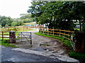
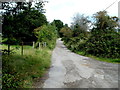
Entrance to The Woodlands, Brickyard Lane, Newport
Brickyard Lane is a semi-rural road from Glasllwch Crescent
to Beau Court Stud and Riding School (ahead).
Image: © Jaggery
Taken: 8 Aug 2011
0.01 miles
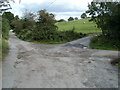
2
Northern end of Brickyard Lane, Newport
Brickyard Lane ends ahead. The road divides into two unnamed lanes.
One leads into Beau Court Stud and Riding School. The other one leads to the former Monmouthshire & Brecon Canal.
Image: © Jaggery
Taken: 8 Aug 2011
0.05 miles
3
Beyond the northern end of Brickyard Lane, Newport
Ahead on the left for the former Monmouthshire & Brecon Canal.
The lane at centre right leads to Beau Court Stud and Riding School.
A few metres beyond the lower right edge of the view is a gate leading to a track to The Woodlands.
Image: © Jaggery
Taken: 8 Aug 2011
0.05 miles
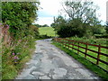
4
Lane descends towards Brickyard Lane, Newport
Beau Court Stud and Riding School http://www.geograph.org.uk/photo/3213193 is behind the camera. The northern end
of Brickyard Lane is ahead. The distant houses are in Glasllwch Crescent.
Image: © Jaggery
Taken: 8 Aug 2011
0.05 miles
5
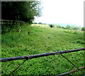
Field on the NW side of Brickyard Lane, Newport
For most of its length behind the camera, this side of Brickyard Lane has been at the edge of a slip road at M4 motorway junction 27. Here the two routes diverge. The wooden fence runs parallel with the slip road.
Image: © Jaggery
Taken: 8 Aug 2011
0.06 miles
6
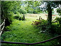
Field viewed across a bent bar, Brickyard Lane, Newport
Viewed from this http://www.geograph.org.uk/photo/3213074 gate.
Image: © Jaggery
Taken: 8 Aug 2011
0.08 miles
7
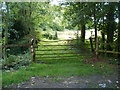
Bent top bar on a field gate, Brickyard Lane, Newport
I don't know how the bar became bent, but the cause was definitely not this contributor sitting on it...
Image: © Jaggery
Taken: 8 Aug 2011
0.08 miles
8
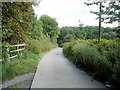
Brickyard Lane, Newport
The brickyard is long gone. The present-day Brickyard Lane has a rural feel, somewhat tempered by the presence of a motorway slip road at M4 motorway junction 27 on the other side of the hedges on the left. The lane leads to Beau Court Stud and Riding School.
Image: © Jaggery
Taken: 8 Aug 2011
0.09 miles
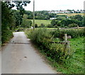
9
Unnamed lane north from Brickyard Lane, Newport
The lane heads north away from this http://www.geograph.org.uk/photo/3213170 junction
towards the former Monmouthshire & Brecon Canal.
Image: © Jaggery
Taken: 8 Aug 2011
0.09 miles
10
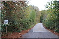
Brickyard Lane
Minor road off Glasllwch Crescent; an M4 slip road at junction 27 is just to the left.
Image: © M J Roscoe
Taken: 27 Oct 2018
0.12 miles