IMAGES TAKEN NEAR TO
Friars Road, NEWPORT, NP20 4FA
Introduction
This page details the photographs taken nearby to Friars Road, NP20 4FA by members of the Geograph project.
The Geograph project started in 2005 with the aim of publishing, organising and preserving representative images for every square kilometre of Great Britain, Ireland and the Isle of Man.

There are currently over 7.5m images from over14,400 individuals and you can help contribute to the project by visiting https://www.geograph.org.uk
Image Map
Images are licensed for reuse under creativecommons.org/licenses/by-sa/2.0
Notes
- Clicking on the map will re-center to the selected point.
- The higher the marker number, the further away the image location is from the centre of the postcode.
Image Listing (569 Images Found)
Images are licensed for reuse under creativecommons.org/licenses/by-sa/2.0
Image
Details
Distance
1
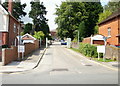
Southern entrance to St Woolos Hospital, Newport
This entrance, from Friars Road, is at an elevation about 15 metres (50 feet) lower than the northern entrance http://www.geograph.org.uk/photo/1628503 from Stow Hill
Image: © Jaggery
Taken: 13 Aug 2009
0.02 miles
2
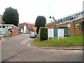
Road junction, St Woolos Hospital, Newport
Viewed from near the Friars Road entrance. http://www.geograph.org.uk/photo/1473698
Ahead for the entrance http://www.geograph.org.uk/photo/2243456 to the southern section of the hospital, or turn right for other sections.
Image: © Jaggery
Taken: 23 Jan 2011
0.02 miles
3
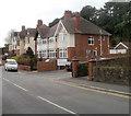
Newport : Friars Road houses adjacent to hospital entrance
The right turn http://www.geograph.org.uk/photo/1473698 is the southern entrance road into St Woolos Hospital. The houses are opposite Belle Vue Park bowling green. http://www.geograph.org.uk/photo/1564249
Image: © Jaggery
Taken: 27 Jan 2011
0.02 miles
4
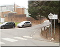
Probably the smallest bus stop pole in Newport
Located at the SE corner of St Woolos Hospital grounds, near the Friars Road exit.
Behind the normal-sized Pedestrian Walkway sign, a bus stop sign is on a pole little more than a metre (about 4 feet) high. The stop is used by Newport Bus service 98, which provides a shuttle service from the city centre bus station to St Woolos Hospital and the Royal Gwent Hospital every day except Sunday.
Image: © Jaggery
Taken: 31 Jan 2011
0.02 miles
5
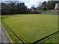
Western bowling green, Belle Vue Park, Newport
This is one of two bowling greens at the Friars Road end of Belle Vue Park.
The green is a square with sides of 40 metres. Generally, greens are built square and as close to 40 metres as possible. This enables games to be played in either direction. Playing in different directions evens out the wear on the green. In addition, the bowlers do not need to face into the sun when playing.
In the distance is Friars Road and Burton Alms Houses. http://www.geograph.org.uk/photo/1472559
Image: © Jaggery
Taken: 3 Mar 2012
0.02 miles
6
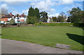
Eastern bowling green, Belle Vue Park, Newport
This is one of two bowling greens at the Friars Road end of Belle Vue Park.
The green is a square with sides of 40 metres. Generally, greens are built square and as close to 40 metres as possible. This enables games to be played in either direction. Playing in different directions evens out the wear on the green. In addition, the bowlers do not need to face into the sun when playing.
In the middle distance, behind the flagpole, is Belle Vue Lodge http://www.geograph.org.uk/photo/1596268 at the northern edge of the park.
Image: © Jaggery
Taken: 3 Mar 2012
0.02 miles
7
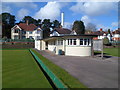
Pavilion, Belle Vue Park bowling greens, Newport
Located between the two http://www.geograph.org.uk/photo/2833329 http://www.geograph.org.uk/photo/2833333 bowling greens at the Friars Road side of Belle Vue Park.
Image: © Jaggery
Taken: 3 Mar 2012
0.02 miles
8
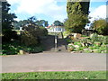
Steps up to Belle Vue Park bowling greens, Newport
The steps lead up to a pavilion http://www.geograph.org.uk/photo/2833338 and two full-sized bowling greens.
Image: © Jaggery
Taken: 3 Mar 2012
0.02 miles
9
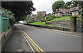
No parking in Friars Road, Newport
Double yellow lines on both sides of Friars Road indicate no parking at any time.
Burton Alms Houses are on the right. The perimeter wall and railings of Belle Vue Park are on the left.
Image: © Jaggery
Taken: 11 Jul 2016
0.03 miles
10
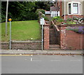
Parking zone G1 for resident permit holders only, Friars Road, Newport
The sign outside 46 Friars Road states that only G1 resident permit holders can leave a vehicle
parked here (in the marked area to the right of the double yellow lines) between 8am and 8pm.
Image: © Jaggery
Taken: 11 Jul 2016
0.03 miles