IMAGES TAKEN NEAR TO
Victoria Close, NEWPORT, NP20 4DU
Introduction
This page details the photographs taken nearby to Victoria Close, NP20 4DU by members of the Geograph project.
The Geograph project started in 2005 with the aim of publishing, organising and preserving representative images for every square kilometre of Great Britain, Ireland and the Isle of Man.

There are currently over 7.5m images from over14,400 individuals and you can help contribute to the project by visiting https://www.geograph.org.uk
Image Map
Images are licensed for reuse under creativecommons.org/licenses/by-sa/2.0
Notes
- Clicking on the map will re-center to the selected point.
- The higher the marker number, the further away the image location is from the centre of the postcode.
Image Listing (1605 Images Found)
Images are licensed for reuse under creativecommons.org/licenses/by-sa/2.0
Image
Details
Distance
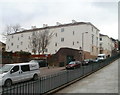
1
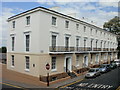
Victoria Place, Newport
Looking towards Stow Hill.
Image: © Chris Brown
Taken: 6 Dec 2016
0.01 miles
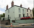
2
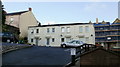
Victoria Close, Newport
4 residential properties in Victoria Close, adjoining Victoria Place.
Image: © Jaggery
Taken: 16 Nov 2009
0.01 miles
3
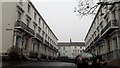
Northern side of Victoria Place, Newport
One of two opposing terraces http://www.geograph.org.uk/photo/4085836 built c1840. Restored in 1977, both terraces are Grade II listed.
Viewed from the elevated pavement on the west side of Stow Hill.
Image: © Jaggery
Taken: 13 Jun 2010
0.01 miles
4
Stow Passage, Newport
A narrow arch on the left side of 82 Stow Hill leads to a narrow (1 metre wide) passageway to a lane from the corner of Jones Street and North Street.
Image: © Jaggery
Taken: 13 Jun 2010
0.01 miles
5
Corner of Victoria Road and Victoria Place, Newport
The houses are located opposite a large church at the top of Hill Street. http://www.geograph.org.uk/photo/1181447
Image: © Jaggery
Taken: 13 Jun 2010
0.01 miles
6
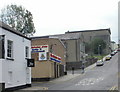
Newport : south side of Hill Street
Viewed from the corner of Commercial Street. In contrast to the north side of the street, which has mainly terraced houses, http://www.geograph.org.uk/photo/1181451 this side of the street is dominated by four large buildings.
Jazz Hair Company at 2 Hill Street is on the corner of Commercial Street.
The Salvation Army Citadel http://www.geograph.org.uk/photo/1585015 extends into Ivor Street.
On the other corner of Ivor Street and Hill Street is the Welsh Church. http://www.geograph.org.uk/photo/1912304
At the top of the hill, on the corner of Victoria Road, is the United Reformed Church. http://www.geograph.org.uk/photo/1181447
Image: © Jaggery
Taken: 13 Jun 2010
0.01 miles
7
Rear view of the northern terrace, Victoria Place, Newport
The view up Stow Hill of the Grade II listed terrace, http://www.geograph.org.uk/photo/1911906 dating from about 1840.
Image: © Jaggery
Taken: 27 Jan 2011
0.01 miles
8
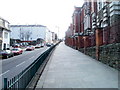
Newport : Stow Hill elevated pavement alongside St Woolos Primary School
Looking up Stow Hill past St Woolos Primary School. http://www.geograph.org.uk/photo/707701
For almost the entire section of Stow Hill from St Woolos Cathedral to the city centre, the pavement on the west side is above road level. Here, it is about a metre higher. Alongside the cathedral, it is several metres higher.
Image: © Jaggery
Taken: 6 Mar 2011
0.01 miles
9
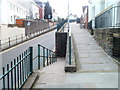
Ramp from elevated pavement to roadway, Stow Hill, Newport
Almost opposite Victoria Place, http://www.geograph.org.uk/photo/1911906 the ramp connects the elevated pavement on the west side of Stow Hill with the roadway. Pedestrians need to be careful crossing the road after descending the ramp, because a slight bend in the road means that vehicles descending the hill cannot be seen until only a few metres away.
Image: © Jaggery
Taken: 6 Mar 2011
0.01 miles
10

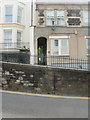
Blue plaque, Victoria Place, Newport
A plaque on the wall of a house in Victoria Place http://www.geograph.org.uk/photo/1911906 records
VICTORIA PLACE
1844
RENNIE-LOGAN, BUILDERS OF THE TOWN
DOCK, ERECTED THIS REGENCY STYLE
TERRACE ON LAND GIVEN BY WILLIAM
TOWNSEND TO PROVIDE ACCESS TO
STOW HILL FROM THE SOUTH EAST.
Image: © Jaggery
Taken: 6 Mar 2011
0.01 miles