IMAGES TAKEN NEAR TO
Lansdowne Road, NEWPORT, NP20 3FZ
Introduction
This page details the photographs taken nearby to Lansdowne Road, NP20 3FZ by members of the Geograph project.
The Geograph project started in 2005 with the aim of publishing, organising and preserving representative images for every square kilometre of Great Britain, Ireland and the Isle of Man.

There are currently over 7.5m images from over14,400 individuals and you can help contribute to the project by visiting https://www.geograph.org.uk
Image Map
Images are licensed for reuse under creativecommons.org/licenses/by-sa/2.0
Notes
- Clicking on the map will re-center to the selected point.
- The higher the marker number, the further away the image location is from the centre of the postcode.
Image Listing (238 Images Found)
Images are licensed for reuse under creativecommons.org/licenses/by-sa/2.0
Image
Details
Distance
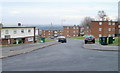
1
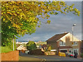
Evening view over Newport (1)
Taken from the junction of Gaer Road and the upper end of Lansdowne Road.
With Uskmouth Power Station https://www.geograph.org.uk/photo/5237263 on the horizon and the Severn Estuary beyond.
Image: © Robin Drayton
Taken: 3 May 2019
0.02 miles
2
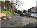
Gaer Road becomes a footpath, Newport
A short distance beyond this junction with Lansdowne Road, Gaer Road can be seen narrowing to a footpath. The footpath continues for about 100 metres southeastwards before widening into a road again at the far end of Lansdowne Road, to continue as Gaer Road down to Cardiff Road.
Image: © Jaggery
Taken: 3 Dec 2009
0.03 miles
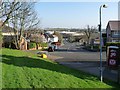
3
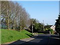
Gaer Road, Newport
The upper part of Gaer Road approaching the footpath http://www.geograph.org.uk/photo/2364139 .
Image: © Robin Drayton
Taken: 23 Mar 2011
0.03 miles
4
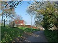
Footpath, Gaer Road, Newport
This is the footpath that links two parts of Gaer Road http://www.geograph.org.uk/photo/2364172.
Image: © Robin Drayton
Taken: 23 Mar 2011
0.04 miles
5
![Installation of Solar Photovoltaic Panels [2]](https://s2.geograph.org.uk/geophotos/02/69/35/2693574_926bbea9_120x120.jpg)
Installation of Solar Photovoltaic Panels [2]
These bungalows are part of the housing stock of Newport City Homes a not-for-profit Registered Social Landlord.
Image: © Robin Drayton
Taken: 12 Nov 2011
0.05 miles
6
Rupert Brooke Drive, Newport
The view south from near the corner of Byron Drive. On the right are flats in Boswell Close, Buchan Close and Arnold Close.
Image: © Jaggery
Taken: 22 Nov 2010
0.06 miles
7
![Installation of Solar Photovoltaic Panels [1]](https://s1.geograph.org.uk/geophotos/02/69/35/2693569_946743e0_120x120.jpg)
Installation of Solar Photovoltaic Panels [1]
These bungalows are part of the housing stock of Newport City Homes a not-for-profit Registered Social Landlord.
Image: © Robin Drayton
Taken: 12 Nov 2011
0.06 miles
8
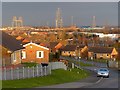
Evening view over Newport
The setting sun shining through a gap in the predominately dark clouds gave this short lived dramatic lighting.
See http://www.geograph.org.uk/photo/2953152 for a similar view but with more usual lighting.
The historic Transporter Bridge http://www.geograph.org.uk/photo/3257047 is at the upper left.
Taken from Drinkwater Gardens in the Gaer area of Newport.
Image: © Robin Drayton
Taken: 10 Mar 2016
0.07 miles
9
Gaer Road, Newport
The view down Gaer Road towards the junction with Cardiff Road at the bottom of the hill.
The present day Gaer Road follows the route of the original farm track from the lodge on Cardiff Road http://www.geograph.org.uk/photo/687505 to Gaer Fach farmhouse (now the Gaer Inn http://www.geograph.org.uk/photo/537653 ).
Part of this route, being rather steep, remains as a footpath http://www.geograph.org.uk/photo/2364139 .
Image: © Robin Drayton
Taken: 23 Mar 2011
0.07 miles
10
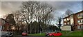
Trees with ash die back, Gaer Estate, Newport
Newport City Council have earmarked these for removal.
They are used as a roost by 100+ jackdaws.
Image: © Robin Drayton
Taken: 31 Jan 2022
0.08 miles