IMAGES TAKEN NEAR TO
Monmouth Castle Drive, NEWPORT, NP20 2QS
Introduction
This page details the photographs taken nearby to Monmouth Castle Drive, NP20 2QS by members of the Geograph project.
The Geograph project started in 2005 with the aim of publishing, organising and preserving representative images for every square kilometre of Great Britain, Ireland and the Isle of Man.

There are currently over 7.5m images from over14,400 individuals and you can help contribute to the project by visiting https://www.geograph.org.uk
Image Map
Images are licensed for reuse under creativecommons.org/licenses/by-sa/2.0
Notes
- Clicking on the map will re-center to the selected point.
- The higher the marker number, the further away the image location is from the centre of the postcode.
Image Listing (74 Images Found)
Images are licensed for reuse under creativecommons.org/licenses/by-sa/2.0
Image
Details
Distance
1
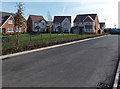
New houses in Mon Bank, Newport
This late October 2013 view is of some of the first houses to be built in the Redrow development,
Mon Bank, on former railway land on the SE side of Cardiff Road.
Image: © Jaggery
Taken: 24 Oct 2013
0.05 miles
2
Abrupt end of the road in Mon Bank, Newport
Although signs at a new junction http://www.geograph.org.uk/photo/3736246 on Cardiff Road indicate that this is a through road, it isn't yet! Work is ongoing at the Redrow housing development Mon Bank, located on former railway land.
Eventually this will be a through road.
Image: © Jaggery
Taken: 24 Oct 2013
0.05 miles
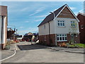
3

Show houses, Mon Bank, Newport
These houses are part of a large development on an area of former railway sidings that was previously known as Monmouthshire Bank.
This is at the junction of Monmouth Castle Drive and Windsor Castle Road. Both names of steam locomotives.
Image: © Robin Drayton
Taken: 12 Oct 2017
0.06 miles
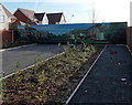
4

Children?s play area, Mon Bank, Newport
Image: © Robin Drayton
Taken: 20 Aug 2021
0.06 miles
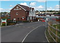
5

Redrow Homes site office, Mon Bank, Newport
Viewed in July 2014 during ongoing house construction on former railway land south of Cardiff Road.
Image: © Jaggery
Taken: 12 Jul 2014
0.09 miles
6
Towards a barrier in the SE part of Mon Bank, Newport
In July 2014, the grey gates in the background are as far as the general public can go in this SE part of Mon Bank, a Redrow housing development of former railway land. Eventually there will be a through road to the Cardiff Road side of Mon Bank.
Image: © Jaggery
Taken: 20 Jul 2014
0.09 miles
7

Jing Xing Ltd, Port Road, Newport
Located in unit 8, Port Road, Maesglas Industrial Estate, in premises formerly occupied by ATS Euromaster. Jing Xing is an importer, wholesaler and retailer of Chinese groceries and food products.
Image: © Jaggery
Taken: 5 Feb 2013
0.11 miles
8

Poundstretcher, Newport
Located on the north side of Port Road in Maesglas Retail Estate.
The premises were formerly occupied by a No Frills DIY superstore. http://www.geograph.org.uk/photo/1995172
Image: © Jaggery
Taken: 2 Nov 2012
0.12 miles
9
Unnamed street in Mon Bank, Newport
In July 2014 this part of the Redrow Homes Mon Bank development on former railway land
was not yet named. The street is a few metres east of Downton Hall Close. http://www.geograph.org.uk/photo/4071185
Image: © Jaggery
Taken: 12 Jul 2014
0.13 miles
10

Vacant premises, Maesglas Retail Park, Newport
The premises, on the south side of Port Road, are to let. Previously occupied by UKBW bathrooms showroom.
Image: © Jaggery
Taken: 28 Jul 2010
0.15 miles