IMAGES TAKEN NEAR TO
Alexandra Road, NEWPORT, NP20 2GY
Introduction
This page details the photographs taken nearby to Alexandra Road, NP20 2GY by members of the Geograph project.
The Geograph project started in 2005 with the aim of publishing, organising and preserving representative images for every square kilometre of Great Britain, Ireland and the Isle of Man.

There are currently over 7.5m images from over14,400 individuals and you can help contribute to the project by visiting https://www.geograph.org.uk
Image Map
Images are licensed for reuse under creativecommons.org/licenses/by-sa/2.0
Notes
- Clicking on the map will re-center to the selected point.
- The higher the marker number, the further away the image location is from the centre of the postcode.
Image Listing (223 Images Found)
Images are licensed for reuse under creativecommons.org/licenses/by-sa/2.0
Image
Details
Distance
1
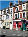
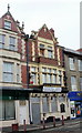
Sizzor Sisters Unisex Salon, Newport
The nameboard of the salon at 18 Alexandra Road shows that the Sizzor Sisters are JoJo and Kirsty.
Image: © Jaggery
Taken: 20 Jul 2014
0.01 miles
2
The view NW along Church Street, Newport
Viewed from opposite The Greenhouse, looking past the Ship and Pilot http://www.geograph.org.uk/photo/1964268 on the corner of St Michael Street, towards the corner of Commercial Road and Alexandra Road in the distance.
Image: © Jaggery
Taken: 5 Oct 2009
0.01 miles
3
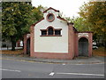
Former Gentlemen's Convenience, Pill, Newport
Permanently closed former public convenience located at the northern end of Alexandra Road (or the southern end of Commercial Road), near the corner of Courtybella Terrace.
Image: © Jaggery
Taken: 5 Oct 2009
0.01 miles
4
Pillgwenlly Library and Information Centre, Newport
Located at 110-111 Commercial Road, Pill, this is one of eleven community libraries run by Newport City Council. The formal name 'Pillgwenlly' is used, whereas 'Pill' is the one used locally. The branch opened in January 2009, replacing the previous Pill branch http://www.geograph.org.uk/photo/2199751 in Temple Street.
Image: © Jaggery
Taken: 5 Oct 2009
0.01 miles
5
Former The Cambrian, Newport
Metal sheets cover the door and ground floor windows of a former pub in Pill at 112 Commercial Road. On the left is the library. http://www.geograph.org.uk/photo/1975553
Image: © Jaggery
Taken: 5 Oct 2009
0.01 miles
6
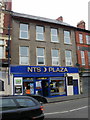
NTS Plaza, Pill, Newport
Internet cafe at 113-114 Commercial Road, next door to the now closed The Cambrian pub. http://www.geograph.org.uk/photo/1975561
Image: © Jaggery
Taken: 5 Oct 2009
0.01 miles
7
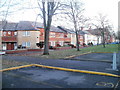
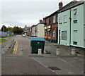
Courtybella Terrace, Newport
Houses on the north side of Courtybella Terrace. The view is in the direction of Alexandra Road.
Image: © Jaggery
Taken: 15 Dec 2010
0.01 miles
8
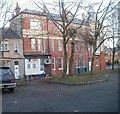
Side view of former Cambrian Inn, Newport
This is the Courtybella Terrace side of the closed pub, the Cambrian, http://www.geograph.org.uk/photo/1975561 which had its frontage on Commercial Road. The pub had an internal layout resembling an L. The building on the corner was not part of the pub, and is currently the Pill branch http://www.geograph.org.uk/photo/1975553 of the City of Newport library and information service.
Image: © Jaggery
Taken: 15 Dec 2010
0.01 miles
9
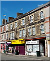
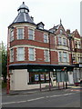
General stores and convenience store in Alexandra Road, Newport
M&A's general stores on the right, Pillgwenlly Convenience Store (a Premier Store) on the left.
Image: © Jaggery
Taken: 20 Jul 2014
0.01 miles
10
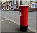
King Edward VII pillarbox, Alexandra Road, Newport
King Edward VII reigned from the death of his mother Queen Victoria
aged 81 on January 22nd 1901 until his own death on May 6th 1910, aged 68.
Image: © Jaggery
Taken: 29 Oct 2017
0.01 miles