IMAGES TAKEN NEAR TO
Barnstaple Court, NEWPORT, NP20 2FU
Introduction
This page details the photographs taken nearby to Barnstaple Court, NP20 2FU by members of the Geograph project.
The Geograph project started in 2005 with the aim of publishing, organising and preserving representative images for every square kilometre of Great Britain, Ireland and the Isle of Man.

There are currently over 7.5m images from over14,400 individuals and you can help contribute to the project by visiting https://www.geograph.org.uk
Image Map
Images are licensed for reuse under creativecommons.org/licenses/by-sa/2.0
Notes
- Clicking on the map will re-center to the selected point.
- The higher the marker number, the further away the image location is from the centre of the postcode.
Image Listing (152 Images Found)
Images are licensed for reuse under creativecommons.org/licenses/by-sa/2.0
Image
Details
Distance
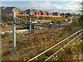
1
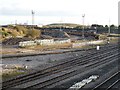
Monmouthshire Bank Sidings, Maesglas
This area is used for the recycling of railway ballast.
The main South Wales railway line is in the foreground.
Image: © Robin Drayton
Taken: 1 Dec 2008
0.06 miles
2

Cae Brynton Road
This was once the junction of Cae Brynton Road with Cardiff Road. It was closed off over 40 years ago, but it is only in the past few years that this has been recognised by some automated route generation systems.
The land in the distance is Monmouthshire Bank Sidings, railway land that is now earmarked for residential development.
Image: © Robin Drayton
Taken: 1 Dec 2008
0.09 miles
3

Tesco train passing through Newport
The train is en-route from Daventry to the Wentloog freight terminal http://www.geograph.org.uk/photo/370674 on the outskirts of Cardiff. It is operated by Stobart Rail and Direct Rail Services.
The land on the far side of the track is being prepared for a housing development. This area was once a mass of railway sidings. See http://www.geograph.org.uk/photo/1135819 for an earlier view of this site.
Image: © Robin Drayton
Taken: 9 Jul 2012
0.10 miles
4

Show houses, Mon Bank, Newport
These houses are the first of a new large development on an area of former railway land that was previously known as Monmouthshire Bank.
Image: © Robin Drayton
Taken: 2 Sep 2013
0.12 miles
5
Towards Alexandra Dock Junction, Newport
Viewed from the edge of a new railway bridge. http://www.geograph.org.uk/photo/3736275 To the right of the bank, fence and vegetation,
a railway spur from the edge of Mendalgief Road heads SW towards the South Wales main line at Alexandra Dock Junction.
Image: © Jaggery
Taken: 24 Oct 2013
0.12 miles
6

The Red Dragon passes through Newport (2)
Ex-Great Western Hall class locomotive 4965 Rood Ashton Hall hauls the Red Dragon excursion return leg from Cardiff to Tyseley, Birmingham.
See Image for the outward journey.
Image: © Robin Drayton
Taken: 7 Mar 2015
0.12 miles
7
Redrow Homes site office, Mon Bank, Newport
Viewed in July 2014 during ongoing house construction on former railway land south of Cardiff Road.
Image: © Jaggery
Taken: 12 Jul 2014
0.12 miles
8
A glimpse of Alexandra Dock Junction, Newport
For those who are not railway employees, or without a pass, many railway views can only be taken from trains, or from far away, as here. This is a view from Cardiff Road across the trackbed of a disused industrial railway line towards the South Wales main line adjacent to Alexandra Dock Junction.
Old maps show this area full of railway lines and sidings, most now gone.
Image: © Jaggery
Taken: 24 Oct 2013
0.13 miles
9
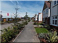
Pavement through Mon Bank, Newport
Viewed in July 2014 during ongoing house construction by Redrow Homes on former railway land south of Cardiff Road.
Image: © Jaggery
Taken: 12 Jul 2014
0.13 miles
10
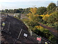
Slow progress with railway electrification, Newport
The electrification of the South Wales Mainline from London to Cardiff has been delayed and is now scheduled to be completed sometime in 2019.
Gantries for the overhead cables have been erected but the cabling has yet to be completed.
The houses in the background are part of a recent development on what was once railway sidings.
See http://www.geograph.org.uk/photo/1135819 for a photo of this location in 2008 and https://www.geograph.org.uk/photo/3032227 for a photo in 2012.
Image: © Robin Drayton
Taken: 19 Nov 2018
0.13 miles