IMAGES TAKEN NEAR TO
Church Street, NEWPORT, NP20 2BY
Introduction
This page details the photographs taken nearby to Church Street, NP20 2BY by members of the Geograph project.
The Geograph project started in 2005 with the aim of publishing, organising and preserving representative images for every square kilometre of Great Britain, Ireland and the Isle of Man.

There are currently over 7.5m images from over14,400 individuals and you can help contribute to the project by visiting https://www.geograph.org.uk
Image Map
Images are licensed for reuse under creativecommons.org/licenses/by-sa/2.0
Notes
- Clicking on the map will re-center to the selected point.
- The higher the marker number, the further away the image location is from the centre of the postcode.
Image Listing (199 Images Found)
Images are licensed for reuse under creativecommons.org/licenses/by-sa/2.0
Image
Details
Distance
1
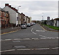
Church Street, Pill, Newport
From Commercial Road along Church Street towards St Michael Street in the Pill area of Newport.
The 20mph speed limit increases to 30mph.
Image: © Jaggery
Taken: 29 Oct 2017
0.04 miles
2
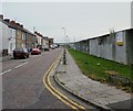
Church Street, Pill, Newport
The view from the southern end of Commercial Road.
Image: © Jaggery
Taken: 5 Oct 2009
0.04 miles
3
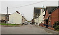
St Michael Street, Newport
Viewed from the corner of Castle Street.
On the right in the middle distance is St Michael's RC Church. http://www.geograph.org.uk/photo/1600989
A small part of a tower of the Transporter Bridge http://www.geograph.org.uk/photo/1624855 can be seen above the roofs on the left.
Image: © Jaggery
Taken: 5 Oct 2009
0.04 miles
4
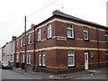
Newport : corner of Clarence Street and St Michael Street, Pill
The street name sign is a rare surviving example of the former practice of including Pill (the usual local shortening of Pillgwenlly) in street signs in this area of Newport.
Image: © Jaggery
Taken: 5 Oct 2009
0.04 miles
5
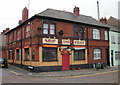
Ship and Pilot, Newport
A pub of characterful appearance, located on the corner of Church Street and St Michael Street. The pub dates back well over a century, to a time when Newport Docks and these surrounding areas were a hive of activity (principally because of the export of coal from the Welsh valleys).
Image: © Jaggery
Taken: 5 Oct 2009
0.04 miles
6
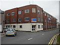
Black Clawson, Newport
Here at Black Clawson's Newelco Works, Church Street, Newport, machinery for the recycled board industry is designed and built.
A remnant of an earlier occupier of the building can be seen on the second floor, above the entrance door. Inscribed on a grey stone plaque is USKSIDE IRON WORKS.
Image: © Jaggery
Taken: 5 Oct 2009
0.04 miles
7
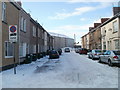
Wilson Street, Newport
Viewed from the far end of King's Parade.
Image: © Jaggery
Taken: 24 Dec 2010
0.04 miles
8
Clarence Street, Newport
Viewed from the corner of St Michael Street. St Michael's RC church http://www.geograph.org.uk/photo/1600989 is on the right.
Image: © Jaggery
Taken: 5 Oct 2009
0.05 miles
9
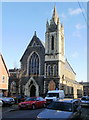
St Michaels RC Church, Newport
Located on the corner of St Michael Street and Clarence Street. Late Victorian Roman Catholic church : the foundation stone was laid in August 1886.
Image: © Jaggery
Taken: 30 Nov 2009
0.05 miles
10
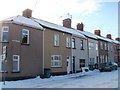
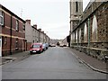
Linton Street, Newport
Houses on the south side of the street, viewed from the corner of King's Parade, looking towards Castle Street. The north side of the street is occupied by the edges of houses in King's Parade and Castle Street.
Image: © Jaggery
Taken: 24 Dec 2010
0.05 miles