IMAGES TAKEN NEAR TO
Havelock Street, NEWPORT, NP20 1JX
Introduction
This page details the photographs taken nearby to Havelock Street, NP20 1JX by members of the Geograph project.
The Geograph project started in 2005 with the aim of publishing, organising and preserving representative images for every square kilometre of Great Britain, Ireland and the Isle of Man.

There are currently over 7.5m images from over14,400 individuals and you can help contribute to the project by visiting https://www.geograph.org.uk
Image Map
Images are licensed for reuse under creativecommons.org/licenses/by-sa/2.0
Notes
- Clicking on the map will re-center to the selected point.
- The higher the marker number, the further away the image location is from the centre of the postcode.
Image Listing (2878 Images Found)
Images are licensed for reuse under creativecommons.org/licenses/by-sa/2.0
Image
Details
Distance
1
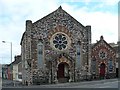
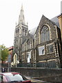
Havelock Street Presbyterian Church
This Grade II listed Church was built in 1863 and is a typical example of the polychromatic Italianate style of architecture.
Image: © Robin Drayton
Taken: 25 Apr 2009
0.01 miles

3
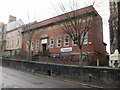
Gap Community Centre, Stow Hill, Newport
Located at 42 Stow Hill, in the former Stow Hill Swimming Baths building.
The Gap Centre is a community and conference centre, dedicated to serving the community of Stow Hill and Baneswell, and also the whole of the city of Newport. The Centre has conference and event facilities for businesses.
The pavements and premises on the western side of Stow Hill are raised several feet above the level of the road, as seen here.
Image: © Jaggery
Taken: 20 Dec 2009
0.01 miles
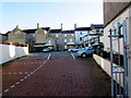
4
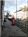
West side of lower Stow Hill, Newport
The view along the raised pavement on the west side of Stow Hill,
looking towards the city centre from the corner of Havelock Street.
The tatty pillarbox has the VR insignia (Victorian). http://www.geograph.org.uk/photo/4749532
Image: © Jaggery
Taken: 20 Dec 2009
0.01 miles
5
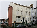
Gwent Education Multi-Ethnic Support Service, Newport
Newport City Council premises at 25 Stow Hill. Grade II listed building
Image: © Jaggery
Taken: 31 Jan 2010
0.01 miles
6
Bethel Community Church, Stow Hill, Newport
Located on the elevated western side of Stow Hill, on the corner of Wesley Place.
Formerly Stow Hill Wesleyan Methodist Church.
Image: © Jaggery
Taken: 19 Sep 2009
0.01 miles
7

Site of former Stow Hill drill hall, Newport
Viewed from the elevated pavement on the west side of Stow Hill.
A fenced-off site on the corner of Stow Hill and School Lane contains the rubble of the demolished Stow Hill Drill Hall, erected in 1875. A car park, beyond the right edge of the photo, occupies the major part of the site once occupied by the drill hall.
Image: © Jaggery
Taken: 21 Aug 2010
0.01 miles
8
Night Lodge car park, Newport
On the east side of North Street, at the rear of the Night Lodge hotel at 52-54 Stow Hill. http://www.geograph.org.uk/photo/1628010
Image: © Jaggery
Taken: 21 Nov 2015
0.01 miles
9
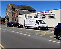
Baneswell Club premises and van, Newport
Social club viewed across Havelock Street from the corner of Stow Hill.
Image: © Jaggery
Taken: 22 Jun 2018
0.01 miles
10
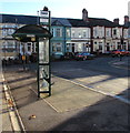
Havelock Street bus stop and shelter, Newport
Near the Stow Hill junction at the edge of the Baneswell area of Newport.
This stop is for buses away from the city centre, up Stow Hill
towards St Woolos Cathedral, the Handpost area and locations beyond.
Image: © Jaggery
Taken: 21 Nov 2015
0.01 miles