IMAGES TAKEN NEAR TO
Kensington Place, NEWPORT, NP19 8GL
Introduction
This page details the photographs taken nearby to Kensington Place, NP19 8GL by members of the Geograph project.
The Geograph project started in 2005 with the aim of publishing, organising and preserving representative images for every square kilometre of Great Britain, Ireland and the Isle of Man.

There are currently over 7.5m images from over14,400 individuals and you can help contribute to the project by visiting https://www.geograph.org.uk
Image Map
Images are licensed for reuse under creativecommons.org/licenses/by-sa/2.0
Notes
- Clicking on the map will re-center to the selected point.
- The higher the marker number, the further away the image location is from the centre of the postcode.
Image Listing (362 Images Found)
Images are licensed for reuse under creativecommons.org/licenses/by-sa/2.0
Image
Details
Distance
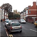
1
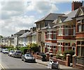
Kensington Place, Newport
Houses on the west side of Kensington Place, viewed from the corner of Oaklands Road, looking towards Chepstow Road.
Image: © Jaggery
Taken: 27 May 2010
0.02 miles
2

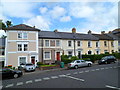
Housing variety, St John's Road, Newport
In this part of St John's Road, opposite St John the Evangelist church, are a detached house on the left, two semi-detached houses in the middle, and a row of six houses on the right, near the corner of Kensington Place.
Image: © Jaggery
Taken: 9 Jun 2012
0.02 miles
3
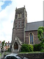
Tower, Grade II listed Church of St John the Evangelist, Newport
The tower, at the western end of the church, was completed in 1911, 51 years after
the church opened for worship in 1860. The church was Grade II listed in February 1980.
Image: © Jaggery
Taken: 9 Jun 2012
0.02 miles
4
Kensington Place houses, Newport
Viewed from opposite the St John the Evangelist church tower, http://www.geograph.org.uk/photo/2987118 at the western end of St John's Road.
Image: © Jaggery
Taken: 9 Jun 2012
0.02 miles
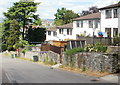
5
West side of Kensington Grove, Newport
Houses on the west side of a cul-de-sac on the north side of Chepstow Road.
Grade II listed St John the Evangelist church http://www.geograph.org.uk/photo/1880568 is in the distance.
Image: © Jaggery
Taken: 23 Dec 2015
0.04 miles
6
Kensington Grove, Newport
Kensington Grove is a 60-metre long cul-de-sac on the north side of Chepstow Road.
Ahead is the derelict and roofless Grade II listed former Lawns Club. http://www.geograph.org.uk/photo/2987542
Image: © Jaggery
Taken: 17 Oct 2013
0.04 miles
7
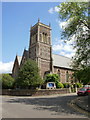
Grade II listed St John the Evangelist church, Newport
Located on the corner of St John's Road and Kensington Place. The Church in Wales church is in the parish of Maindee, diocese of Monmouth. It opened for worship in 1860. It was Grade II listed in February 1980.
Image: © Jaggery
Taken: 27 May 2010
0.04 miles
8
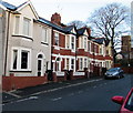
Oaklands Road, Newport
Houses on the north side of Oaklands Road, looking in the direction of Kensington Place.
Image: © Jaggery
Taken: 27 May 2010
0.04 miles
9
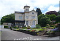
Grade II listed Cambrian House, Newport
Located on the north side of St John's Road, Cambrian House is currently occupied by St David's Foundation Hospice Care.
A blue plaque http://www.geograph.org.uk/photo/2986984 on the building records that the building dates from 1854 (though the year 1859 appears on a tablet above the doorway). It was built for Thomas Spittle, who developed the Cambrian foundry on a site later known as Spittle's Point. He also owned works on the east bank (of the River Usk) where three iron ships were launched.
Cambrian House was Grade II listed in February 1980.
Image: © Jaggery
Taken: 9 Jun 2012
0.04 miles
10
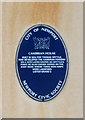
Blue plaque, Cambrian House, Newport
The plaque is fixed to the wall of this http://www.geograph.org.uk/photo/2986980 Grade II listed building.
Image: © Jaggery
Taken: 9 Jun 2012
0.04 miles