IMAGES TAKEN NEAR TO
Lockwood Court, NEWPORT, NP19 4AQ
Introduction
This page details the photographs taken nearby to Lockwood Court, NP19 4AQ by members of the Geograph project.
The Geograph project started in 2005 with the aim of publishing, organising and preserving representative images for every square kilometre of Great Britain, Ireland and the Isle of Man.

There are currently over 7.5m images from over14,400 individuals and you can help contribute to the project by visiting https://www.geograph.org.uk
Image Map
Images are licensed for reuse under creativecommons.org/licenses/by-sa/2.0
Notes
- Clicking on the map will re-center to the selected point.
- The higher the marker number, the further away the image location is from the centre of the postcode.
Image Listing (95 Images Found)
Images are licensed for reuse under creativecommons.org/licenses/by-sa/2.0
Image
Details
Distance
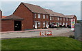
1
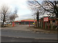
Robert Price, Corporation Road, Newport
Builders' merchants premises located on Corporation Road, just south of the Spytty Road junction.
Image: © Jaggery
Taken: 18 Dec 2009
0.03 miles
2
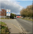
Corporation Road, Newport
Looking north from the top end of the industrial part of Corporation Road towards the junction with Spytty Road and East Dock Road.
Image: © Jaggery
Taken: 5 Nov 2009
0.03 miles
3
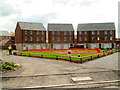
Far end of Lysaght Way, Lysaght Village, Newport
Viewed from the edge of Lysaght Way. The housing is in a section of Lysaght Village http://www.geograph.org.uk/photo/2539967 without, as yet (early August 2011), a street name sign. Newer houses at the left edge of the view do not yet have roofs.
Image: © Jaggery
Taken: 5 Aug 2011
0.03 miles
4
Building site, Lysaght Village, Newport
In early August 2011, there are houses http://www.geograph.org.uk/photo/2539972 on the west side of the Lysaght Village site whereas the eastern side is a building site.
Image: © Jaggery
Taken: 5 Aug 2011
0.03 miles
5

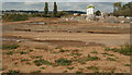
Site of Orb steelworks
The full site of Orb steelworks occupies 74 acres. This 22 acre portion has been cleared for the creation of a housing development to be named Lysaght Village.
John Lysaght of Wolverhampton established a steelworks on this site in 1898 and in its heyday it employed over 3000 people.
In the background is the City Bridge http://www.geograph.org.uk/photo/1140452 .
Image: © Robin Drayton
Taken: 9 Dec 2009
0.04 miles
6
Clarke Road, Lysaght Village, Newport
Viewed from Lysaght Way in early May 2014. Clarke Road and its houses are recent additions to the Taylor Wimpey housing development on land formerly in the NE corner of the Tata Steel Orb steelworks site (originally Lysaght Orb steelworks). The small building on the left (black door) is a GTC electricity substation, identifier N0011635 LYSAGHT VILLAGE.
Image: © Jaggery
Taken: 5 May 2014
0.05 miles
7
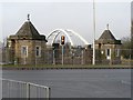
Former entrance to Orb steelworks
22 acres of the Orb Steelworks site is being levelled in preparation for a new housing development.
It appears that this distinctive entrance gateway is being retained.
See also Image
Image: © Robin Drayton
Taken: 9 Dec 2009
0.06 miles
8
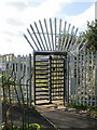
Entrance turnstile, Orb, Corporation Road, Newport
Pedestrian entrance to Orb Electrical Steels on Corporation Road. The turnstile is operated by an entry card.
Image: © Jaggery
Taken: 5 Nov 2009
0.07 miles
9
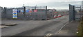
Entrance to Lawson site, Corporation Road, Newport
Lawson are engaged in demolishing the buildings on the north-east side of the Orb Works site, in preparation for the erection of housing.
Image: © Jaggery
Taken: 18 Dec 2009
0.07 miles
10
Lysaght Way, Lysaght Village, Newport
Newly-built houses viewed across Corporation Road. Lysaght Village occupies land http://www.geograph.org.uk/photo/1621101 formerly part of Orb steelworks.
Image: © Jaggery
Taken: 5 Aug 2011
0.07 miles