IMAGES TAKEN NEAR TO
Reene Court, NEWPORT, NP19 0RJ
Introduction
This page details the photographs taken nearby to Reene Court, NP19 0RJ by members of the Geograph project.
The Geograph project started in 2005 with the aim of publishing, organising and preserving representative images for every square kilometre of Great Britain, Ireland and the Isle of Man.

There are currently over 7.5m images from over14,400 individuals and you can help contribute to the project by visiting https://www.geograph.org.uk
Image Map
Images are licensed for reuse under creativecommons.org/licenses/by-sa/2.0
Notes
- Clicking on the map will re-center to the selected point.
- The higher the marker number, the further away the image location is from the centre of the postcode.
Image Listing (191 Images Found)
Images are licensed for reuse under creativecommons.org/licenses/by-sa/2.0
Image
Details
Distance
1
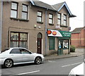
Liswerry Post Office, Newport
Post Office on the corner of Somerton Road and Kitty Hawk Drive.
Image: © Jaggery
Taken: 24 Sep 2009
0.02 miles
2
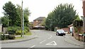
Kitty Hawk Drive, Newport
Viewed from the corner of Somerton Road, Kitty Hawk Drive is the connecting road through an area of modern houses with aviation-themed street names, such as Amy Johnson Close and Bleriot Close.
Image: © Jaggery
Taken: 24 Sep 2009
0.02 miles
3
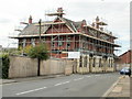
Former The King pub, Liswerry, Newport
The photo taken on September 24th 2009 shows the former 'The King' pub on Somerton Road encased in scaffolding, ready for demolition, to be replaced by residential development. The pub was formerly 'The King of Prussia'. It was a popular venue for a pre-match drink before football games at Somerton Park,http://www.geograph.org.uk/photo/1225331 itself long since converted into residential properties.http://www.geograph.org.uk/photo/1678682
Image: © Jaggery
Taken: 24 Sep 2009
0.04 miles
4
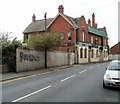
Derelict former King pub, Newport
This view along Somerton Road shows a dilapidated building that was formerly the King pub, also known for some time as the King of Prussia.
The local newspaper reported in 2008 that the building was to be demolished and replaced with flats. This seemed to be the case in this scaffold-encased view http://www.geograph.org.uk/photo/1504590 taken in September 2009.
But now, nearly 2 years later, the scaffolding is gone but the pub building remains...
Image: © Jaggery
Taken: 10 Aug 2011
0.04 miles
5
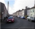
Downing Street, Newport
Dead-end street extending for 180 metres from Somerton Road (behind the camera) to Liswerry Pill Reen, a drainage channel.
Image: © Jaggery
Taken: 16 Feb 2016
0.04 miles
6
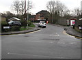
Kitty Hawk Drive, Liswerry, Newport
Looking south across Somerton Road in March 2020.
The Kitty Hawk Drive name signs show that the road ahead is not a through route.
Image: © Jaggery
Taken: 5 Mar 2020
0.05 miles
7
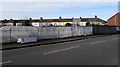
Fenced-off site of the former King pub, Somerton, Newport
Viewed across Somerton Road in February 2016.
This was the location of the King pub, seen here http://www.geograph.org.uk/photo/1504590 in September 2009.
Image: © Jaggery
Taken: 16 Feb 2016
0.05 miles
8
Corner of Kitty Hawk Drive and Somerton Road, Liswerry, Newport
The Kitty Hawk Drive name sign shows that the road on the left is not a through route.
Image: © Jaggery
Taken: 5 Mar 2020
0.05 miles
9

JCDecaux advertising hoardings, Somerton Road, Newport
Viewed across Somerton Road. Frobisher Road is on the left.
JCDecaux is the largest outdoor advertising corporation in the world.
Image: © Jaggery
Taken: 16 Feb 2016
0.06 miles
10
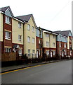
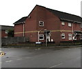
21st century housing, Somerton Road, Newport
Viewed in March 2020. The site was formerly occupied by the King pub seen here https://www.geograph.org.uk/photo/1504590 awaiting demolition in 2009.
Image: © Jaggery
Taken: 5 Mar 2020
0.06 miles