IMAGES TAKEN NEAR TO
NP1 8NZ
Introduction
This page details the photographs taken nearby to NP1 8NZ by members of the Geograph project.
The Geograph project started in 2005 with the aim of publishing, organising and preserving representative images for every square kilometre of Great Britain, Ireland and the Isle of Man.

There are currently over 7.5m images from over14,400 individuals and you can help contribute to the project by visiting https://www.geograph.org.uk
Image Map
Images are licensed for reuse under creativecommons.org/licenses/by-sa/2.0
Notes
- Clicking on the map will re-center to the selected point.
- The higher the marker number, the further away the image location is from the centre of the postcode.
Image Listing (37 Images Found)
Images are licensed for reuse under creativecommons.org/licenses/by-sa/2.0
Image
Details
Distance
1
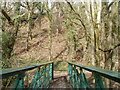
Steep ground on the north side of River Rhymney footbridge, Machen
Looking north across this footbridge. http://www.geograph.org.uk/photo/2763538
The footpath to the A468 is on the left side of the end of the footbridge. The direct route to the A468 would be straight up the steep bank ahead - not recommended!
Image: © Jaggery
Taken: 26 Feb 2011
0.06 miles
2
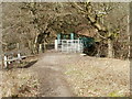
Kissing gate at southern edge of River Rhymney footbridge
The river footbridge connects the northern side of the Machen Forge Trail with a path to the A468 on the far side of the bridge.
Image: © Jaggery
Taken: 26 Feb 2011
0.06 miles
3
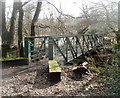
Footbridge over the Rhymney, Machen
The footbridge carries a footpath across the Rhymney River into the northern part Machen Forge Trail, a 5km (3 mile) circular walk through a former industrial area that has now reverted mainly to nature, with a few relics, here and there, of its past.
Image: © Jaggery
Taken: 26 Feb 2011
0.06 miles
4
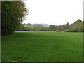
Field by Machen Forge Trail
In the distance is Caerphilly Mountain.
Image: © John Light
Taken: 17 May 2012
0.07 miles
5
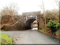
Former railway bridge near White Hart Inn, Machen
The low bridge (headroom 8' 6") now carries National Cycle Network route 4.
The left turn is into the White Hart Inn site. http://www.geograph.org.uk/photo/2763147
Image: © Jaggery
Taken: 26 Feb 2011
0.09 miles
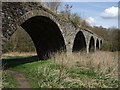
6
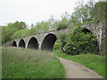
Viaduct on the Machen Forge Trail
This used to carry the line between Caerphilly and Machen.
Image: © John Light
Taken: 17 May 2012
0.09 miles
7
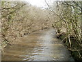
River Rhymney downstream from a footbridge at the edge of Machen Forge Trail
Viewed from this footbridge. http://www.geograph.org.uk/photo/2763538
Image: © Jaggery
Taken: 26 Feb 2011
0.09 miles
8
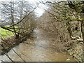
River Rhymney upstream from a footbridge at the edge of Machen Forge Trail
Viewed from this footbridge.http://www.geograph.org.uk/photo/2763538
Image: © Jaggery
Taken: 26 Feb 2011
0.09 miles
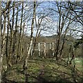
9
Machen Viaduct, Machen Forge Trail
Machen Forge Trail is a rural walk through villages and countryside, covering the old industrial area of Machen and Waterloo.
Image: © Kev Griffin
Taken: 5 Apr 2009
0.09 miles
10
No Entry atop Machen Viaduct, Machen Forge Trail
For safety reasons, this fence denies access to walk on top of the viaduct. The photo is taken on the path where the railway once lay.
Machen Forge Trail is a rural walk through villages and countryside, covering the old industrial area of Machen and Waterloo.
Image: © Kev Griffin
Taken: 5 Apr 2009
0.10 miles