IMAGES TAKEN NEAR TO
White Ash Glade, NEWPORT, NP18 3RB
Introduction
This page details the photographs taken nearby to White Ash Glade, NP18 3RB by members of the Geograph project.
The Geograph project started in 2005 with the aim of publishing, organising and preserving representative images for every square kilometre of Great Britain, Ireland and the Isle of Man.

There are currently over 7.5m images from over14,400 individuals and you can help contribute to the project by visiting https://www.geograph.org.uk
Image Map
Images are licensed for reuse under creativecommons.org/licenses/by-sa/2.0
Notes
- Clicking on the map will re-center to the selected point.
- The higher the marker number, the further away the image location is from the centre of the postcode.
Image Listing (98 Images Found)
Images are licensed for reuse under creativecommons.org/licenses/by-sa/2.0
Image
Details
Distance
1
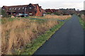
White Ash Glade, Caerleon
The southern edge of White Ash Glade is on the left, viewed from National Cycle Network route 88.
Image: © Jaggery
Taken: 3 Jan 2014
0.01 miles
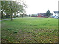
2
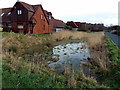
Temporary pond near White Ash Glade, Caerleon
Viewed on January 3rd 2014, shortly after an exceptionally high tide
on the River Usk caused widespread flooding in this area.
Image: © Jaggery
Taken: 3 Jan 2014
0.02 miles
3
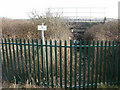
Not dedicated to the public, Caerleon
The small notice on a pole states:
Highways Act 1980
The British Railways Board hereby gives notice that this way is not dedicated to the public.
As a high, spike-topped fence is between the Malpas to Caerleon cycleway and a muddy, partially water-covered track under a railway bridge, I'd guess that most passing members of the public do not need a notice to deter them from attempting to enter railway property.
Image: © Jaggery
Taken: 13 Mar 2010
0.04 miles
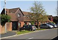
4
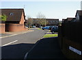
Elder Close, Caerleon
Some deep shadows but much bright sunshine mid-afternoon in Elder Close on a cloudless Saturday in mid April. Viewed from Roman Reach.
Image: © Jaggery
Taken: 17 Apr 2010
0.04 miles
5
Open space at Caerleon end of cycle route from Malpas
A roughly rectangular open space separates houses in Home Farm Crescent and Elder Close from the cycle route and footpath.
Image: © Jaggery
Taken: 16 Oct 2010
0.04 miles
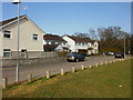
6
White Ash Glade, Caerleon
Houses on the east side of White Ash Glade, viewed from Roman Reach.
Image: © Jaggery
Taken: 17 Apr 2010
0.05 miles
7
Home Farm Crescent, Caerleon
Houses at the southeast edge of Home Farm Crescent, adjacent to the Caerleon end of the riverside cycleway/footpath from Malpas.
Image: © Jaggery
Taken: 13 Mar 2010
0.08 miles
8
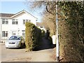
Footpath from Home Farm Crescent, Caerleon
The footpath heads along the edge of a small wooded area, away from the southeast corner of Home Farm Crescent.
Image: © Jaggery
Taken: 14 Mar 2010
0.08 miles
9
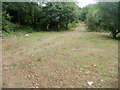
A track through woods, Caerleon
Viewed from National Cycle Network Route 88. http://www.geograph.org.uk/photo/2494691
Image: © Jaggery
Taken: 5 Jul 2011
0.08 miles
10
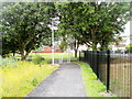
National Cycle Network Route 88 approaches Home Farm Crescent, Caerleon
This section of the footpath and cycle route, http://www.geograph.org.uk/photo/2494687 from Caerleon Comprehensive School, opened in June 2011.
Image: © Jaggery
Taken: 5 Jul 2011
0.08 miles