IMAGES TAKEN NEAR TO
Hartridge Farm Road, NEWPORT, NP18 2LL
Introduction
This page details the photographs taken nearby to Hartridge Farm Road, NP18 2LL by members of the Geograph project.
The Geograph project started in 2005 with the aim of publishing, organising and preserving representative images for every square kilometre of Great Britain, Ireland and the Isle of Man.

There are currently over 7.5m images from over14,400 individuals and you can help contribute to the project by visiting https://www.geograph.org.uk
Image Map
Images are licensed for reuse under creativecommons.org/licenses/by-sa/2.0
Notes
- Clicking on the map will re-center to the selected point.
- The higher the marker number, the further away the image location is from the centre of the postcode.
Image Listing (37 Images Found)
Images are licensed for reuse under creativecommons.org/licenses/by-sa/2.0
Image
Details
Distance
1
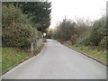
Newport : Hartridge Farm Road south of the schools
South of Hartridge High School http://www.geograph.org.uk/photo/2176609 and Ysgol Gymraeg Casnewydd, http://www.geograph.org.uk/photo/2176598 Hartridge Farm Road heads towards an RSPCA animal shelter and a road safety centre.
Image: © Jaggery
Taken: 26 Nov 2010
0.03 miles
2
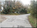
Fork ahead, Hartridge Farm Road, Newport
Near its southern end, Hartridge Farm Road bends to the right. Just around the corner are entrances to an RSPCA animal shelter and a road safety centre. On the left, a lane leads to the western side of Llanwern golf course.
Image: © Jaggery
Taken: 26 Nov 2010
0.03 miles
3
Road Safety Centre, Newport
The entrance drive from Hartridge Farm Road to Capita Gwent Consultancy's Road Safety Centre. Located next door to an RSPCA animal centre.
Image: © Jaggery
Taken: 26 Nov 2010
0.03 miles
4
Visitors' entrance, RSPCA animal centre, Newport
Located at the southern end of Hartridge Farm Road.
The centre looks after cats, dogs, rabbits and other domestic animals. Typically, more than 100 animals are at the centre. Most of them have been rescued from neglect or bad treatment by their previous owners. The centre spends as much time as needed (usually a few weeks, sometimes months), preparing them for a new life and a second chance. The centre, financed entirely by public donations, is open 6 days a week (11.30am to 4pm). Closed all day on Thursdays. In addition to animal adoption, other services available here are dog training and microchipping.
Image: © Jaggery
Taken: 26 Nov 2010
0.03 miles
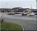
5
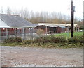
Southern side of RSPCA premises, Newport
Some of the buildings for animals at the RSPCA animal centre http://www.geograph.org.uk/photo/2176829 at the far end of Hartridge Farm Road.
Image: © Jaggery
Taken: 26 Nov 2010
0.03 miles
6
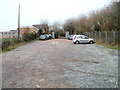
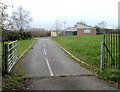
Visitors' car park, RSPCA animal centre, Newport
The view from the far end towards the visitors' entrance building on the left. http://www.geograph.org.uk/photo/2176829
Image: © Jaggery
Taken: 26 Nov 2010
0.03 miles
7
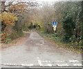
Lane from Hartridge Farm Road to Llanwern golf course
Near the southern end of Hartridge Farm Road, a lane heads eastwards towards a small group of houses, and a path to Llanwern golf course. In case the No Through Road sign is not clear enough, a text sign underneath states
NO WAY THROUGH FOR VEHICLES
PARKING PROHIBITED
The third sign, with a yellow triangle, states that this is a neighbourhood watch area.
Image: © Jaggery
Taken: 26 Nov 2010
0.04 miles
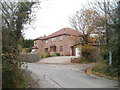
8
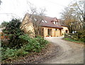
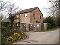
Ty Melyn, Newport
House located on the lane http://www.geograph.org.uk/photo/2176674 from Hartridge Farm Road to Llanwern golf course.
Image: © Jaggery
Taken: 26 Nov 2010
0.06 miles
9
Corner houses, Hartridge Farm Road, Newport
Two semi-detached houses located on the corner of Hartridge Farm Road and a lane http://www.geograph.org.uk/photo/2176674 to Llanwern golf course.
Image: © Jaggery
Taken: 26 Nov 2010
0.06 miles
10
Ysgol Gymraeg Casnewydd, Newport
The school is located on Hartridge Farm Road, alongside Hartridge High School.
The purpose-built school buildings date from 1993. There are about 400 pupils enrolled, aged from 3 to 11. The total includes about 45 part time nursery children. The main medium of instruction is in the Welsh language, though the English language is not neglected : one of the school's priorities is to develop Welsh and English bilingualism by promoting dual skills.
Image: © Jaggery
Taken: 26 Nov 2010
0.06 miles