IMAGES TAKEN NEAR TO
Pye Corner, NEWPORT, NP18 2BT
Introduction
This page details the photographs taken nearby to Pye Corner, NP18 2BT by members of the Geograph project.
The Geograph project started in 2005 with the aim of publishing, organising and preserving representative images for every square kilometre of Great Britain, Ireland and the Isle of Man.

There are currently over 7.5m images from over14,400 individuals and you can help contribute to the project by visiting https://www.geograph.org.uk
Image Map
Images are licensed for reuse under creativecommons.org/licenses/by-sa/2.0
Notes
- Clicking on the map will re-center to the selected point.
- The higher the marker number, the further away the image location is from the centre of the postcode.
Image Listing (36 Images Found)
Images are licensed for reuse under creativecommons.org/licenses/by-sa/2.0
Image
Details
Distance
1
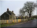
Pye Corner Farm
On the corner of Broadstreet Common and Nash Road and opposite to Image
Grade II listed.
Image: © Robin Drayton
Taken: 9 Dec 2009
0.01 miles
4
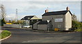
Drainage Board Premises, Pye Corner
Caldicot & Wentlooge Levels Internal Drainage Board premises located on the corner of Nash Road and Broadstreet Common.
Image: © Jaggery
Taken: 5 Nov 2009
0.04 miles
5
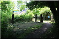
Celtic Trail at Nash Road
The permissive cycle track, NCR 4, crosses a reen to join the road. Compared to two years ago the configuration of the barriers has changed. The metal barriers Image have been removed and there are now wooden posts.
Image: © M J Roscoe
Taken: 6 Jul 2022
0.04 miles
6
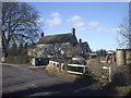
Celtic Trail meets Nash Road
NCR 4 goes over Lakes Reen beyond the barriers to end an off-road section and join the highway at Pye Corner.
Image: © M J Roscoe
Taken: 30 Jul 2020
0.04 miles
7
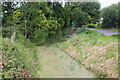
Lakes Reen by Broad Street Common
Roadside land drain.
Image: © M J Roscoe
Taken: 6 Jul 2022
0.05 miles
8
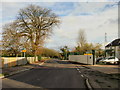
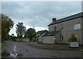
Broadstreet Common, Pye Corner
Broadstreet Common heads away east from Pye Corner. On the right are the Drainage Board premises. http://www.geograph.org.uk/photo/1586340
Image: © Jaggery
Taken: 5 Nov 2009
0.06 miles
9
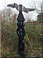
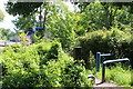
Cycle path milepost, Pye Corner
This is a Rowe type milepost.
To the left, Transporter Bridge 2m.
To the right, Severn Bridge 21m.
Image: © Robin Drayton
Taken: 9 Dec 2009
0.06 miles
10
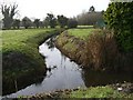
Julian's Reen, Pye Corner
Viewed from Broadstreet Common and adjacent to Image, this is one of the main reens on the Caldicot Level.
Image: © Robin Drayton
Taken: 9 Dec 2009
0.07 miles