IMAGES TAKEN NEAR TO
Wyvern Road, CHEPSTOW, NP16 7HS
Introduction
This page details the photographs taken nearby to Wyvern Road, NP16 7HS by members of the Geograph project.
The Geograph project started in 2005 with the aim of publishing, organising and preserving representative images for every square kilometre of Great Britain, Ireland and the Isle of Man.

There are currently over 7.5m images from over14,400 individuals and you can help contribute to the project by visiting https://www.geograph.org.uk
Image Map
Images are licensed for reuse under creativecommons.org/licenses/by-sa/2.0
Notes
- Clicking on the map will re-center to the selected point.
- The higher the marker number, the further away the image location is from the centre of the postcode.
Image Listing (164 Images Found)
Images are licensed for reuse under creativecommons.org/licenses/by-sa/2.0
Image
Details
Distance
1
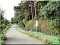
Warning sign, Beachley coastal path
The coastal path runs along the fenced-off southern perimeter of Beachley Barracks. The signs notifies walkers that this is MoD (Ministry of Defence) land and to keep to the path.
Image: © Jaggery
Taken: 17 Sep 2010
0.04 miles
3
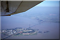
Aerial view - Beachley and Severn and Wye Motorway Bridges
Image: © Colin Park
Taken: 16 Jul 1978
0.08 miles
4
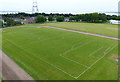
Recreation ground at Beachley
Viewed from the Severn Bridge.
Image: © Mat Fascione
Taken: 7 Jun 2013
0.08 miles
5
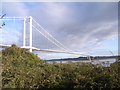
View across M48 Severn Bridge
Image: © Nick Mutton 01329 000000
Taken: 11 Nov 2007
0.08 miles
6
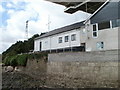
Beachley Rescue Station
SARA (Severn Area Rescue Association) is an inshore rescue boat and land search organisation covering the Severn Estuary, upper reaches of the River Severn, and the rivers Wye, Bristol Avon and Usk. SARA is the largest independent lifeboat service in the UK (second only to the RNLI), with 9 operational boats, 9 Mobile Response Units, 4 lifeboat stations and about 150 personnel.
This was SARA’s first purpose-built lifeboat station. It is situated under the M48 (Old) Severn Bridge on the peninsula between the Severn and Wye.
Image: © Jaggery
Taken: 17 Sep 2010
0.08 miles
7
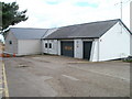
Landside view of rescue station, Beachley
The building is owned by SARA (Severn Area Rescue Association). http://www.geograph.org.uk/photo/2202443
Image: © Jaggery
Taken: 17 Sep 2010
0.08 miles
8
Footpath barrier, Beachley
A barrier prevents vehicles using the coastal path along the southern section of the Beachley peninsula.
Image: © Jaggery
Taken: 17 Sep 2010
0.08 miles
9
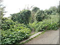
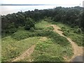
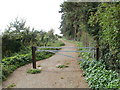
Track to the shore, Beachley
A track to the west bank of the River Severn heads away from the coastal path.
Image: © Jaggery
Taken: 17 Sep 2010
0.08 miles
