IMAGES TAKEN NEAR TO
The Martins, CHEPSTOW, NP16 7DP
Introduction
This page details the photographs taken nearby to The Martins, NP16 7DP by members of the Geograph project.
The Geograph project started in 2005 with the aim of publishing, organising and preserving representative images for every square kilometre of Great Britain, Ireland and the Isle of Man.

There are currently over 7.5m images from over14,400 individuals and you can help contribute to the project by visiting https://www.geograph.org.uk
Image Map
Images are licensed for reuse under creativecommons.org/licenses/by-sa/2.0
Notes
- Clicking on the map will re-center to the selected point.
- The higher the marker number, the further away the image location is from the centre of the postcode.
Image Listing (132 Images Found)
Images are licensed for reuse under creativecommons.org/licenses/by-sa/2.0
Image
Details
Distance
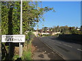
2
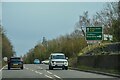
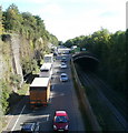
Tidenham : Tutshill - A48
Looking along the A48.
Image: © Lewis Clarke
Taken: 22 Mar 2023
0.06 miles
3
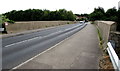
Across Beachley Road bridge, Sedbury
The bridge carries Beachley Road over the A48 road and railway lines on
the Lydney to Chepstow route, about 650 metres northeast of Chepstow railway station.
Image: © Jaggery
Taken: 7 Jul 2016
0.07 miles
5
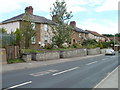
Tubular Cottages, Tutshill
This group of 6 semi-detached houses on the east side of Beachley Road is named Tubular Cottages. A correspondent informs me that Brunel's railway bridge nearby, replaced in the 1960s, was of tubular construction hence the name.
Image: © Jaggery
Taken: 8 Sep 2010
0.07 miles
7
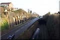
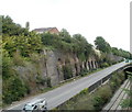
Road and rail
Sharing the same cutting. The newer A48 Tuthill bypass is built partially over the railway line in order to fit it into the same cutting. A northbound train can just be seen.
Image: © Jonathan Billinger
Taken: 28 Dec 2006
0.08 miles
8
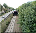
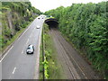
Railway tunnel, Tutshill
Viewed from Beachley Road bridge. A short distance NE of the English bank of the River Wye, the railway lines heading for Lydney enter a 350 metre long tunnel.
Just beyond the far side of the tunnel is the former Wye Valley Junction. http://www.geograph.org.uk/photo/542098
Image: © Jaggery
Taken: 8 Sep 2010
0.08 miles
9
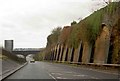
Bank reinforcement, A48, Tutshill
The steep bank on the north side of the A48, a few tens of metres east of the Wye bridge, is held in place by a retaining wall. On the right, the railway lines from Chepstow to Lydney enter a tunnel http://www.geograph.org.uk/photo/2067329
Image: © Jaggery
Taken: 8 Sep 2010
0.08 miles
10
Minor accident, A48, Tutshill
After what appears to be a minor collision on the A48 just east of the Wye Bridge,
traffic is being directed past a car at right angles with the roadway. Viewed from Beachley Road bridge.
Image: © Jaggery
Taken: 17 Sep 2010
0.08 miles