IMAGES TAKEN NEAR TO
Firgrove, CHEPSTOW, NP16 6TQ
Introduction
This page details the photographs taken nearby to Firgrove, NP16 6TQ by members of the Geograph project.
The Geograph project started in 2005 with the aim of publishing, organising and preserving representative images for every square kilometre of Great Britain, Ireland and the Isle of Man.

There are currently over 7.5m images from over14,400 individuals and you can help contribute to the project by visiting https://www.geograph.org.uk
Image Map
Images are licensed for reuse under creativecommons.org/licenses/by-sa/2.0
Notes
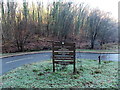
- Clicking on the map will re-center to the selected point.
- The higher the marker number, the further away the image location is from the centre of the postcode.
Image Listing (278 Images Found)
Images are licensed for reuse under creativecommons.org/licenses/by-sa/2.0
Image
Details
Distance
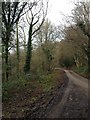
1
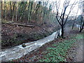
Vigorous Angiddy flows past Lower Wireworks car park, Tintern
Swollen by recent heavy rain, the Angiddy (or Angidy or Anghidi) flows along the edge of this http://www.geograph.org.uk/photo/3819134
car park. Some sources state that the Angiddy is a river, others that it is a stream.
Image: © Jaggery
Taken: 19 Jan 2014
0.02 miles
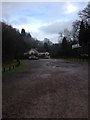
2
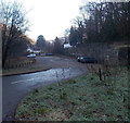
Lower Wireworks car park, Tintern
Free parking area set below Forge Road.
A nearby noticeboard http://www.geograph.org.uk/photo/3819138 shows No coaches, HGVs or overnight parking.
Image: © Jaggery
Taken: 19 Jan 2014
0.02 miles
3
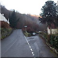
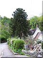
Side road near a Forge Road monkey puzzle, Tintern
The tree is Araucaria araucana, the monkey puzzle tree, an evergreen that can grow to 40 metres (130 ft) tall with a 2 metre (nearly 7 ft) trunk diameter. This one is somewhat smaller!
Image: © Jaggery
Taken: 19 Jan 2014
0.02 miles
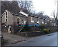
4
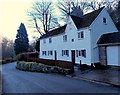
Late 17th century house, Forge Road, Tintern
A small black tablet above the doorway on the right shows EF 1699.
This is the former Lower Wireworks house, now in residential use.
Image: © Jaggery
Taken: 19 Jan 2014
0.02 miles
5
Araucaria tree and house
An Araucaria (monkey-puzzle) tree overshadowing a house in Tintern.
Image: © George Evans
Taken: 3 May 2009
0.03 miles
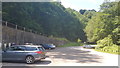
9
Welcome to Lower Wireworks, Tintern
The Monmouthshire County Council board is at the entrance to this http://www.geograph.org.uk/photo/3819134 free car park.
No coaches, HGVs or overnight parking.
Image: © Jaggery
Taken: 19 Jan 2014
0.07 miles
10
Old School House, Tintern
Viewed across Forge Road. Now in residential use. Kelly's Directory of Monmouthshire 1901 stated that this was The National School for boys, girls & infants. Average attendance was 124.
Image: © Jaggery
Taken: 19 Jan 2014
0.07 miles