IMAGES TAKEN NEAR TO
Tintern, CHEPSTOW, NP16 6SF
Introduction
This page details the photographs taken nearby to NP16 6SF by members of the Geograph project.
The Geograph project started in 2005 with the aim of publishing, organising and preserving representative images for every square kilometre of Great Britain, Ireland and the Isle of Man.

There are currently over 7.5m images from over14,400 individuals and you can help contribute to the project by visiting https://www.geograph.org.uk
Image Map
Images are licensed for reuse under creativecommons.org/licenses/by-sa/2.0
Notes
- Clicking on the map will re-center to the selected point.
- The higher the marker number, the further away the image location is from the centre of the postcode.
Image Listing (532 Images Found)
Images are licensed for reuse under creativecommons.org/licenses/by-sa/2.0
Image
Details
Distance
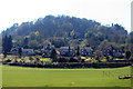
3
The Abbey Hotel at Tintern
Commanding a fine view of the Abbey on the opposite side of the main road.
Image: © Oliver Dixon
Taken: 24 Sep 2011
0.03 miles
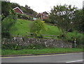
4

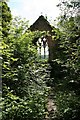
Tintern Parva: St. Mary the Virgin church, The burial ground (other side)
The burial ground situated near the St. Mary the Virgin church, which has been associated with the Tintern Abbey
since 12th Century, is maintained by volunteers from the Parish Church of St Michael and all Angels (situated on
the river Wye bank at Tintern Parva) and by those who tend family graves.
Image: © Alby
Taken: 26 Jun 2006
0.04 miles
5
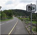
Speed camera sign alongside the A466, Tintern
Facing traffic approaching the centre of the village.
Image: © Jaggery
Taken: 16 Aug 2017
0.04 miles
6
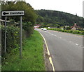
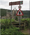
Llanishen direction sign,Tintern
The sign alongside the A466 is about 175 metres from the Forge Road junction. http://www.geograph.org.uk/photo/3819025
Forge Road leads to Llanishen (Monmouthshire). Image
Image: © Jaggery
Taken: 16 Aug 2017
0.04 miles
7
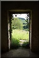
North doorway
Looking north from the door in the tower of the ruined church of St.Mary the Virgin http://www.geograph.org.uk/photo/1372446
Image: © Richard Croft
Taken: 11 Jun 2009
0.04 miles
8
Ruined church of St.Mary the Virgin
Overgrown ruins of the Church of St.Mary the Virgin, view east http://www.geograph.org.uk/photo/1352150 from inside the nave
Image: © Richard Croft
Taken: 11 Jun 2009
0.04 miles
9
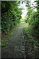
Church path
Ancient overgrown path to the ruined church of St.Mary the Virgin http://www.geograph.org.uk/photo/1352150
Image: © Richard Croft
Taken: 11 Jun 2009
0.04 miles
10
Tintern Abbey/Abaty Tyndyrn direction sign
Alongside the A466. The Abbey ruins http://www.geograph.org.uk/photo/5501499 are in the background.
Image: © Jaggery
Taken: 16 Aug 2017
0.04 miles